You are here: Home > Network List > TA - USArray Transportable Network (new EarthScope stations) Stations List
> Station G22K Bettles, AK, USA > Earthquake Result Viewer
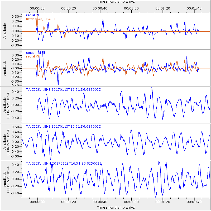
G22K Bettles, AK, USA - Earthquake Result Viewer
*The percent match for this event was below the threshold and hence no stack was calculated.
| Earthquake location: |
Northern Molucca Sea |
| Earthquake latitude/longitude: |
0.0/125.1 |
| Earthquake time(UTC): |
2017/01/13 (013) 16:39:25 GMT |
| Earthquake Depth: |
46 km |
| Earthquake Magnitude: |
5.7 mb |
| Earthquake Catalog/Contributor: |
NEIC PDE/us |
|
| Network: |
TA USArray Transportable Network (new EarthScope stations) |
| Station: |
G22K Bettles, AK, USA |
| Lat/Lon: |
66.92 N/151.51 W |
| Elevation: |
205 m |
|
| Distance: |
87.4 deg |
| Az: |
23.082 deg |
| Baz: |
263.967 deg |
| Ray Param: |
$rayparam |
*The percent match for this event was below the threshold and hence was not used in the summary stack. |
|
| Radial Match: |
58.092667 % |
| Radial Bump: |
400 |
| Transverse Match: |
47.447502 % |
| Transverse Bump: |
400 |
| SOD ConfigId: |
11737051 |
| Insert Time: |
2019-04-26 15:11:41.513 +0000 |
| GWidth: |
2.5 |
| Max Bumps: |
400 |
| Tol: |
0.001 |
|
Signal To Noise
| Channel | StoN | STA | LTA |
| TA:G22K: :BHZ:20170113T16:51:36.625002Z | 1.8605986 | 3.6922222E-7 | 1.984427E-7 |
| TA:G22K: :BHN:20170113T16:51:36.625002Z | 0.3323963 | 7.7109966E-8 | 2.3198203E-7 |
| TA:G22K: :BHE:20170113T16:51:36.625002Z | 1.0402678 | 1.7794423E-7 | 1.7105617E-7 |
| Arrivals |
| Ps | |
| PpPs | |
| PsPs/PpSs | |


