You are here: Home > Network List > IU - Global Seismograph Network (GSN - IRIS/USGS) Stations List
> Station CTAO Charters Towers, Australia > Earthquake Result Viewer
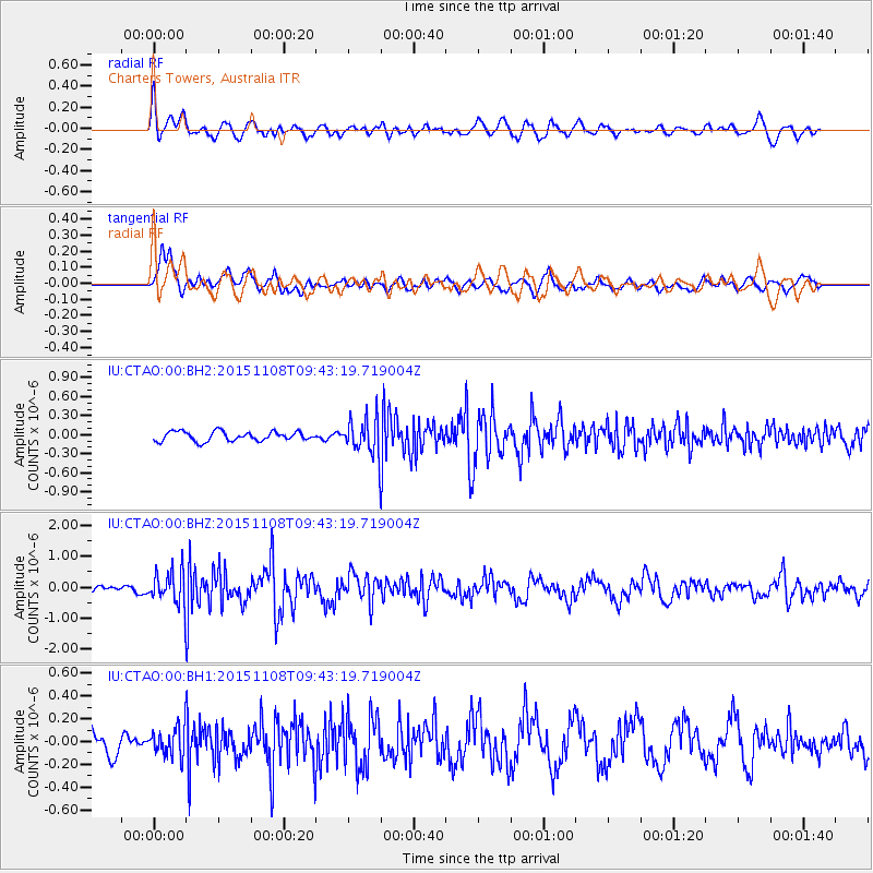
CTAO Charters Towers, Australia - Earthquake Result Viewer
*The percent match for this event was below the threshold and hence no stack was calculated.
| Earthquake location: |
Northern Sumatra, Indonesia |
| Earthquake latitude/longitude: |
0.7/98.9 |
| Earthquake time(UTC): |
2015/11/08 (312) 09:34:57 GMT |
| Earthquake Depth: |
75 km |
| Earthquake Magnitude: |
6.1 MB |
| Earthquake Catalog/Contributor: |
NEIC PDE/NEIC COMCAT |
|
| Network: |
IU Global Seismograph Network (GSN - IRIS/USGS) |
| Station: |
CTAO Charters Towers, Australia |
| Lat/Lon: |
20.09 S/146.25 E |
| Elevation: |
357 m |
|
| Distance: |
50.8 deg |
| Az: |
116.815 deg |
| Baz: |
288.296 deg |
| Ray Param: |
$rayparam |
*The percent match for this event was below the threshold and hence was not used in the summary stack. |
|
| Radial Match: |
63.608093 % |
| Radial Bump: |
400 |
| Transverse Match: |
72.12531 % |
| Transverse Bump: |
400 |
| SOD ConfigId: |
1259291 |
| Insert Time: |
2015-11-22 10:15:39.858 +0000 |
| GWidth: |
2.5 |
| Max Bumps: |
400 |
| Tol: |
0.001 |
|
Signal To Noise
| Channel | StoN | STA | LTA |
| IU:CTAO:00:BHZ:20151108T09:43:19.719004Z | 5.1724615 | 5.6756636E-7 | 1.0972848E-7 |
| IU:CTAO:00:BH1:20151108T09:43:19.719004Z | 1.132933 | 1.3034395E-7 | 1.15050014E-7 |
| IU:CTAO:00:BH2:20151108T09:43:19.719004Z | 3.9003472 | 2.8522263E-7 | 7.312749E-8 |
| Arrivals |
| Ps | |
| PpPs | |
| PsPs/PpSs | |


