You are here: Home > Network List > US - United States National Seismic Network Stations List
> Station EGMT Eagleton, Montana, USA > Earthquake Result Viewer
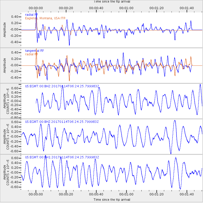
EGMT Eagleton, Montana, USA - Earthquake Result Viewer
*The percent match for this event was below the threshold and hence no stack was calculated.
| Earthquake location: |
Fiji Islands Region |
| Earthquake latitude/longitude: |
-18.6/176.2 |
| Earthquake time(UTC): |
2017/01/14 (014) 06:11:41 GMT |
| Earthquake Depth: |
10 km |
| Earthquake Magnitude: |
6.1 Mwp |
| Earthquake Catalog/Contributor: |
NEIC PDE/us |
|
| Network: |
US United States National Seismic Network |
| Station: |
EGMT Eagleton, Montana, USA |
| Lat/Lon: |
48.02 N/109.75 W |
| Elevation: |
1055 m |
|
| Distance: |
93.4 deg |
| Az: |
40.277 deg |
| Baz: |
245.982 deg |
| Ray Param: |
$rayparam |
*The percent match for this event was below the threshold and hence was not used in the summary stack. |
|
| Radial Match: |
44.53834 % |
| Radial Bump: |
400 |
| Transverse Match: |
65.26061 % |
| Transverse Bump: |
400 |
| SOD ConfigId: |
11737051 |
| Insert Time: |
2019-04-26 15:17:32.148 +0000 |
| GWidth: |
2.5 |
| Max Bumps: |
400 |
| Tol: |
0.001 |
|
Signal To Noise
| Channel | StoN | STA | LTA |
| US:EGMT:00:BHZ:20170114T06:24:25.799983Z | 2.38218 | 3.139005E-7 | 1.3177028E-7 |
| US:EGMT:00:BH1:20170114T06:24:25.799983Z | 1.1185732 | 2.6854352E-7 | 2.4007682E-7 |
| US:EGMT:00:BH2:20170114T06:24:25.799983Z | 0.84088814 | 2.2638065E-7 | 2.6921612E-7 |
| Arrivals |
| Ps | |
| PpPs | |
| PsPs/PpSs | |


