You are here: Home > Network List > YT07 - POLENET Stations List
> Station ALYS ALYS > Earthquake Result Viewer
ALYS ALYS - Earthquake Result Viewer
| Earthquake location: |
Fiji Islands Region |
| Earthquake latitude/longitude: |
-18.6/176.2 |
| Earthquake time(UTC): |
2017/01/14 (014) 06:11:41 GMT |
| Earthquake Depth: |
10 km |
| Earthquake Magnitude: |
6.1 Mwp |
| Earthquake Catalog/Contributor: |
NEIC PDE/us |
|
| Network: |
YT POLENET |
| Station: |
ALYS ALYS |
| Lat/Lon: |
84.35 S/23.73 W |
| Elevation: |
2084 m |
|
| Distance: |
76.9 deg |
| Az: |
178.01 deg |
| Baz: |
199.423 deg |
| Ray Param: |
0.050698206 |
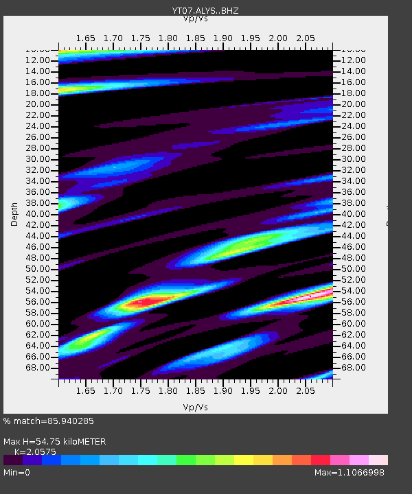
| Estimated Moho Depth: |
54.75 km |
| Estimated Crust Vp/Vs: |
2.06 |
| Assumed Crust Vp: |
6.356 km/s |
| Estimated Crust Vs: |
3.089 km/s |
| Estimated Crust Poisson's Ratio: |
0.35 |
|
| Radial Match: |
85.940285 % |
| Radial Bump: |
400 |
| Transverse Match: |
69.8611 % |
| Transverse Bump: |
400 |
| SOD ConfigId: |
11737051 |
| Insert Time: |
2019-04-26 15:18:15.363 +0000 |
| GWidth: |
2.5 |
| Max Bumps: |
400 |
| Tol: |
0.001 |
|

Signal To Noise
| Channel | StoN | STA | LTA |
| YT:ALYS: :BHZ:20170114T06:23:02.57397Z | 4.3755045 | 7.6148933E-7 | 1.7403464E-7 |
| YT:ALYS: :BHN:20170114T06:23:02.57397Z | 3.2475116 | 4.184934E-7 | 1.2886588E-7 |
| YT:ALYS: :BHE:20170114T06:23:02.57397Z | 0.88132834 | 1.821982E-7 | 2.0673137E-7 |
| Arrivals |
| Ps | 9.3 SECOND |
| PpPs | 26 SECOND |
| PsPs/PpSs | 35 SECOND |


