You are here: Home > Network List > TA - USArray Transportable Network (new EarthScope stations) Stations List
> Station G21K Allakaket, AK, USA > Earthquake Result Viewer
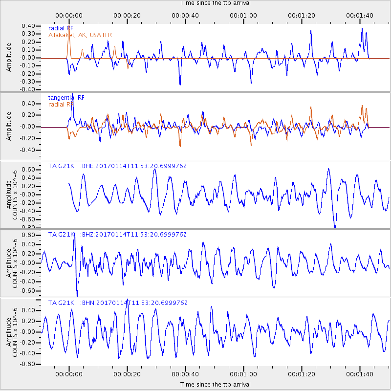
G21K Allakaket, AK, USA - Earthquake Result Viewer
*The percent match for this event was below the threshold and hence no stack was calculated.
| Earthquake location: |
Northern Molucca Sea |
| Earthquake latitude/longitude: |
1.2/126.4 |
| Earthquake time(UTC): |
2017/01/14 (014) 11:41:18 GMT |
| Earthquake Depth: |
23 km |
| Earthquake Magnitude: |
5.6 mb |
| Earthquake Catalog/Contributor: |
NEIC PDE/us |
|
| Network: |
TA USArray Transportable Network (new EarthScope stations) |
| Station: |
G21K Allakaket, AK, USA |
| Lat/Lon: |
66.52 N/153.51 W |
| Elevation: |
446 m |
|
| Distance: |
84.9 deg |
| Az: |
23.35 deg |
| Baz: |
261.403 deg |
| Ray Param: |
$rayparam |
*The percent match for this event was below the threshold and hence was not used in the summary stack. |
|
| Radial Match: |
56.004894 % |
| Radial Bump: |
360 |
| Transverse Match: |
53.851215 % |
| Transverse Bump: |
400 |
| SOD ConfigId: |
11737051 |
| Insert Time: |
2019-04-26 15:22:15.766 +0000 |
| GWidth: |
2.5 |
| Max Bumps: |
400 |
| Tol: |
0.001 |
|
Signal To Noise
| Channel | StoN | STA | LTA |
| TA:G21K: :BHZ:20170114T11:53:20.699976Z | 1.5091454 | 3.1178047E-7 | 2.0659407E-7 |
| TA:G21K: :BHN:20170114T11:53:20.699976Z | 1.93718 | 2.630761E-7 | 1.3580363E-7 |
| TA:G21K: :BHE:20170114T11:53:20.699976Z | 1.7869449 | 3.6659756E-7 | 2.0515324E-7 |
| Arrivals |
| Ps | |
| PpPs | |
| PsPs/PpSs | |


