You are here: Home > Network List > TA - USArray Transportable Network (new EarthScope stations) Stations List
> Station R32K Eaglecrest, AK, USA > Earthquake Result Viewer
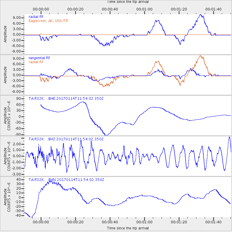
R32K Eaglecrest, AK, USA - Earthquake Result Viewer
*The percent match for this event was below the threshold and hence no stack was calculated.
| Earthquake location: |
Northern Molucca Sea |
| Earthquake latitude/longitude: |
1.2/126.4 |
| Earthquake time(UTC): |
2017/01/14 (014) 11:41:18 GMT |
| Earthquake Depth: |
23 km |
| Earthquake Magnitude: |
5.6 mb |
| Earthquake Catalog/Contributor: |
NEIC PDE/us |
|
| Network: |
TA USArray Transportable Network (new EarthScope stations) |
| Station: |
R32K Eaglecrest, AK, USA |
| Lat/Lon: |
58.27 N/134.52 W |
| Elevation: |
386 m |
|
| Distance: |
93.8 deg |
| Az: |
31.526 deg |
| Baz: |
278.376 deg |
| Ray Param: |
$rayparam |
*The percent match for this event was below the threshold and hence was not used in the summary stack. |
|
| Radial Match: |
8.904457 % |
| Radial Bump: |
400 |
| Transverse Match: |
15.013342 % |
| Transverse Bump: |
400 |
| SOD ConfigId: |
11737051 |
| Insert Time: |
2019-04-26 15:22:31.399 +0000 |
| GWidth: |
2.5 |
| Max Bumps: |
400 |
| Tol: |
0.001 |
|
Signal To Noise
| Channel | StoN | STA | LTA |
| TA:R32K: :BHZ:20170114T11:54:02.350Z | 0.98784626 | 7.6339484E-7 | 7.727871E-7 |
| TA:R32K: :BHN:20170114T11:54:02.350Z | 4.3189435 | 4.585317E-5 | 1.0616756E-5 |
| TA:R32K: :BHE:20170114T11:54:02.350Z | 5.1718245 | 7.867469E-5 | 1.5212173E-5 |
| Arrivals |
| Ps | |
| PpPs | |
| PsPs/PpSs | |


