You are here: Home > Network List > CI - Caltech Regional Seismic Network Stations List
> Station DAN DAN, Needles, CA, USA > Earthquake Result Viewer
DAN DAN, Needles, CA, USA - Earthquake Result Viewer
| Earthquake location: |
El Salvador |
| Earthquake latitude/longitude: |
13.0/-88.7 |
| Earthquake time(UTC): |
2001/01/13 (013) 17:33:32 GMT |
| Earthquake Depth: |
60 km |
| Earthquake Magnitude: |
6.4 MB, 7.8 MS, 7.7 MW, 7.5 ME |
| Earthquake Catalog/Contributor: |
WHDF/NEIC |
|
| Network: |
CI Caltech Regional Seismic Network |
| Station: |
DAN DAN, Needles, CA, USA |
| Lat/Lon: |
34.64 N/115.38 W |
| Elevation: |
428 m |
|
| Distance: |
32.4 deg |
| Az: |
316.165 deg |
| Baz: |
125.06 deg |
| Ray Param: |
0.07854897 |
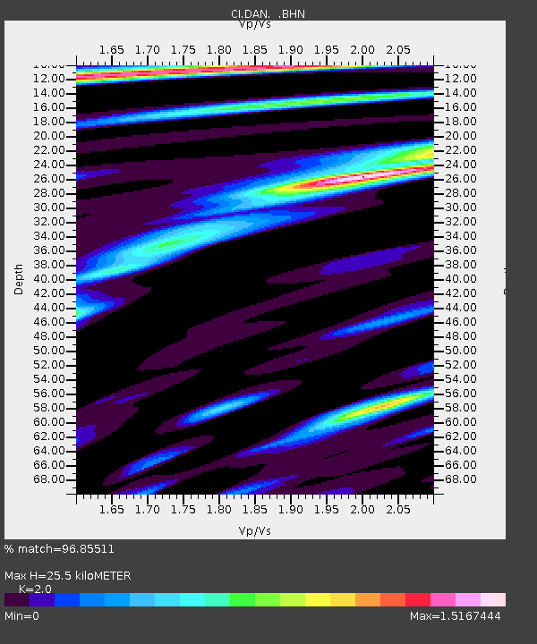
| Estimated Moho Depth: |
25.5 km |
| Estimated Crust Vp/Vs: |
2.00 |
| Assumed Crust Vp: |
6.276 km/s |
| Estimated Crust Vs: |
3.138 km/s |
| Estimated Crust Poisson's Ratio: |
0.33 |
|
| Radial Match: |
96.85511 % |
| Radial Bump: |
400 |
| Transverse Match: |
79.7675 % |
| Transverse Bump: |
400 |
| SOD ConfigId: |
3787 |
| Insert Time: |
2010-02-26 01:00:37.302 +0000 |
| GWidth: |
2.5 |
| Max Bumps: |
400 |
| Tol: |
0.001 |
|
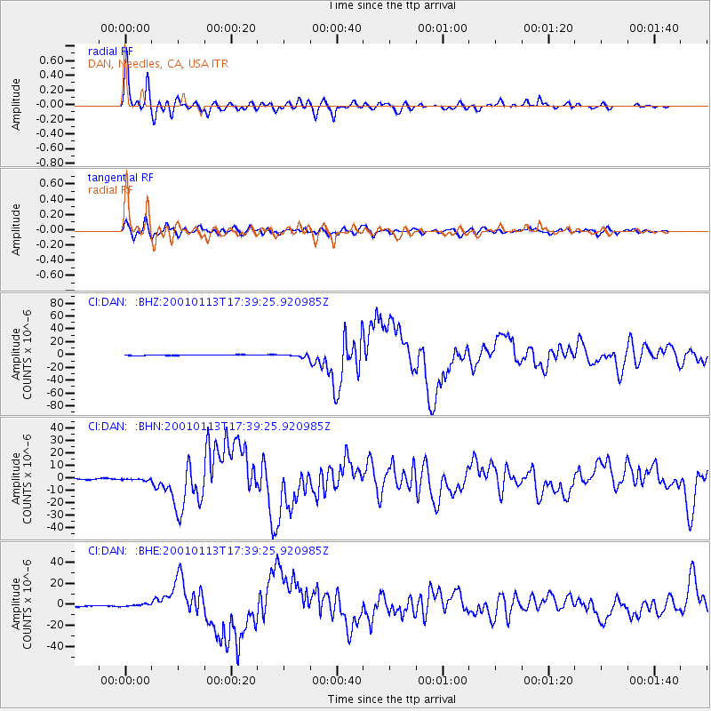
Signal To Noise
| Channel | StoN | STA | LTA |
| CI:DAN: :BHN:20010113T17:39:25.920985Z | 1.096371 | 5.3122994E-7 | 4.845348E-7 |
| CI:DAN: :BHE:20010113T17:39:25.920985Z | 2.4525697 | 1.039652E-6 | 4.2390317E-7 |
| CI:DAN: :BHZ:20010113T17:39:25.920985Z | 3.934796 | 2.085313E-6 | 5.299673E-7 |
| Arrivals |
| Ps | 4.3 SECOND |
| PpPs | 11 SECOND |
| PsPs/PpSs | 16 SECOND |


