You are here: Home > Network List > CI - Caltech Regional Seismic Network Stations List
> Station DGR Domenigoni Reservoir, California, USA > Earthquake Result Viewer
DGR Domenigoni Reservoir, California, USA - Earthquake Result Viewer

| Earthquake location: |
Fiji Islands Region |
| Earthquake latitude/longitude: |
-21.7/-179.5 |
| Earthquake time(UTC): |
2002/08/19 (231) 11:01:01 GMT |
| Earthquake Depth: |
580 km |
| Earthquake Magnitude: |
6.7 MB, 7.6 MW, 7.7 ME |
| Earthquake Catalog/Contributor: |
WHDF/NEIC |
|
| Network: |
CI Caltech Regional Seismic Network |
| Station: |
DGR Domenigoni Reservoir, California, USA |
| Lat/Lon: |
33.65 N/117.01 W |
| Elevation: |
609 m |
|
| Distance: |
81.1 deg |
| Az: |
48.506 deg |
| Baz: |
236.627 deg |
| Ray Param: |
0.046090465 |
| Estimated Moho Depth: |
32.75 km |
| Estimated Crust Vp/Vs: |
1.79 |
| Assumed Crust Vp: |
6.264 km/s |
| Estimated Crust Vs: |
3.509 km/s |
| Estimated Crust Poisson's Ratio: |
0.27 |
|
| Radial Match: |
95.92279 % |
| Radial Bump: |
400 |
| Transverse Match: |
89.862015 % |
| Transverse Bump: |
400 |
| SOD ConfigId: |
3787 |
| Insert Time: |
2010-03-05 21:37:42.762 +0000 |
| GWidth: |
2.5 |
| Max Bumps: |
400 |
| Tol: |
0.001 |
|
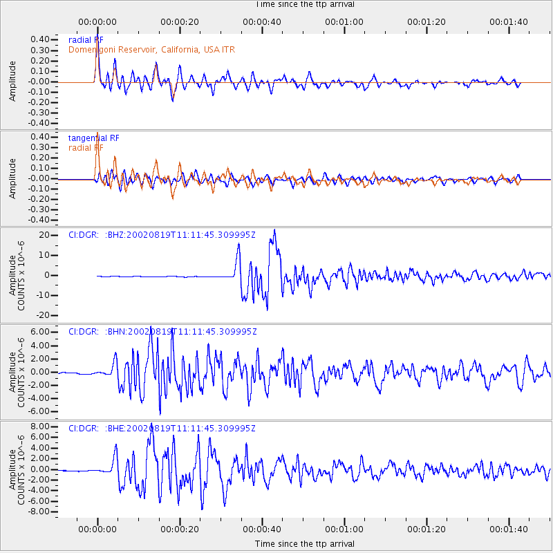
Signal To Noise
| Channel | StoN | STA | LTA |
| CI:DGR: :BHN:20020819T11:11:45.309995Z | 10.825224 | 1.0791127E-6 | 9.9685025E-8 |
| CI:DGR: :BHE:20020819T11:11:45.309995Z | 24.491285 | 1.7063084E-6 | 6.9670016E-8 |
| CI:DGR: :BHZ:20020819T11:11:45.309995Z | 46.768913 | 5.7221005E-6 | 1.2234837E-7 |
| Arrivals |
| Ps | 4.2 SECOND |
| PpPs | 14 SECOND |
| PsPs/PpSs | 18 SECOND |


