You are here: Home > Network List > CI - Caltech Regional Seismic Network Stations List
> Station DGR Domenigoni Reservoir, California, USA > Earthquake Result Viewer
DGR Domenigoni Reservoir, California, USA - Earthquake Result Viewer
| Earthquake location: |
Dominican Republic Region |
| Earthquake latitude/longitude: |
19.8/-70.7 |
| Earthquake time(UTC): |
2003/09/22 (265) 04:45:36 GMT |
| Earthquake Depth: |
10 km |
| Earthquake Magnitude: |
6.2 MB, 6.6 MS, 6.5 MW, 6.4 MW |
| Earthquake Catalog/Contributor: |
WHDF/NEIC |
|
| Network: |
CI Caltech Regional Seismic Network |
| Station: |
DGR Domenigoni Reservoir, California, USA |
| Lat/Lon: |
33.65 N/117.01 W |
| Elevation: |
609 m |
|
| Distance: |
43.3 deg |
| Az: |
298.358 deg |
| Baz: |
96.535 deg |
| Ray Param: |
0.07264648 |
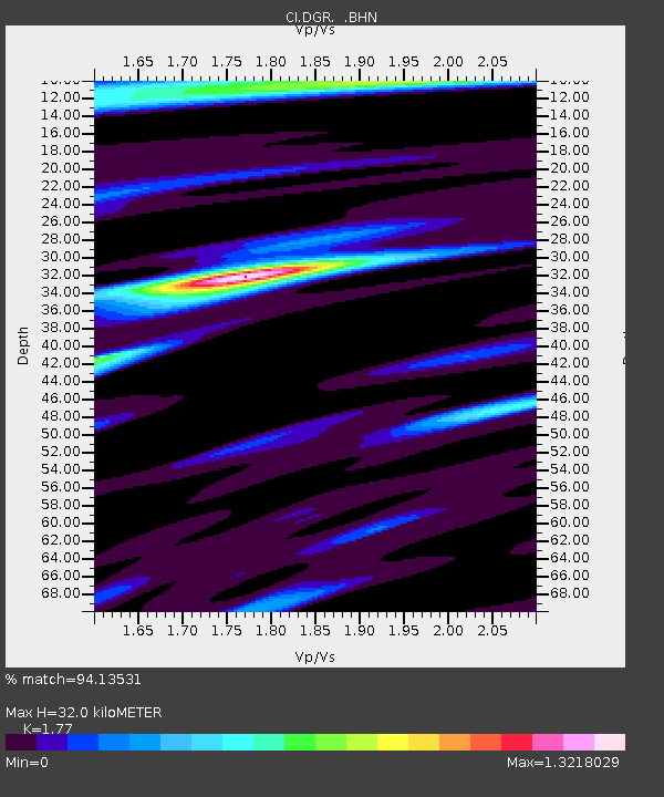
| Estimated Moho Depth: |
32.0 km |
| Estimated Crust Vp/Vs: |
1.77 |
| Assumed Crust Vp: |
6.264 km/s |
| Estimated Crust Vs: |
3.539 km/s |
| Estimated Crust Poisson's Ratio: |
0.27 |
|
| Radial Match: |
94.13531 % |
| Radial Bump: |
311 |
| Transverse Match: |
76.951775 % |
| Transverse Bump: |
400 |
| SOD ConfigId: |
3787 |
| Insert Time: |
2010-03-05 21:38:14.874 +0000 |
| GWidth: |
2.5 |
| Max Bumps: |
400 |
| Tol: |
0.001 |
|

Signal To Noise
| Channel | StoN | STA | LTA |
| CI:DGR: :BHN:20030922T04:53:07.160013Z | 1.1544752 | 1.14205186E-7 | 9.89239E-8 |
| CI:DGR: :BHE:20030922T04:53:07.160013Z | 3.6341834 | 2.7847653E-7 | 7.662699E-8 |
| CI:DGR: :BHZ:20030922T04:53:07.160013Z | 3.8204153 | 4.423161E-7 | 1.1577697E-7 |
| Arrivals |
| Ps | 4.2 SECOND |
| PpPs | 13 SECOND |
| PsPs/PpSs | 17 SECOND |


