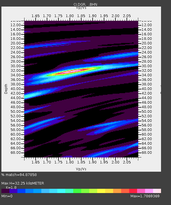
DGR Domenigoni Reservoir, California, USA - Earthquake Result Viewer
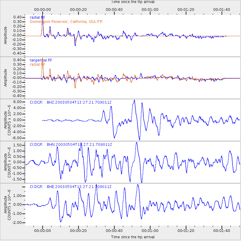
Earthquake location: Kermadec Islands, New Zealand
Earthquake latitude/longitude: -30.5/-178.2
Earthquake time(UTC): 2003/05/04 (124) 13:15:18 GMT
Earthquake Depth: 62 km
Earthquake Magnitude: 6.0 MB, 6.5 MS, 6.7 MW, 6.7 MW
Earthquake Catalog/Contributor: WHDF/NEIC
Network: CI Caltech Regional Seismic Network
Station: DGR Domenigoni Reservoir, California, USA
Lat/Lon: 33.65 N/117.01 W
Elevation: 609 m
Distance: 86.1 deg
Az: 47.122 deg
Baz: 229.29 deg
Ray Param: 0.044165496
Estimated Moho Depth: 32.25 km
Estimated Crust Vp/Vs: 1.80
Assumed Crust Vp: 6.264 km/s
Estimated Crust Vs: 3.48 km/s
Estimated Crust Poisson's Ratio: 0.28
Radial Match: 94.87858 %
Radial Bump: 400
Transverse Match: 87.51226 %
Transverse Bump: 400
SOD ConfigId: 3787
Insert Time: 2010-03-05 21:38:46.018 +0000
GWidth: 2.5
Max Bumps: 400
Tol: 0.001

Signal To Noise

ChannelStoNSTALTA
CI:DGR: :BHN:20030504T13:27:21.709011Z2.57466823.3164903E-71.2881235E-7
CI:DGR: :BHE:20030504T13:27:21.709011Z2.15509582.7347906E-71.268988E-7
CI:DGR: :BHZ:20030504T13:27:21.709011Z8.3394761.3364784E-61.6025928E-7
Arrivals
Ps4.2 SECOND
PpPs14 SECOND
PsPs/PpSs18 SECOND