You are here: Home > Network List > CI - Caltech Regional Seismic Network Stations List
> Station DGR Domenigoni Reservoir, California, USA > Earthquake Result Viewer
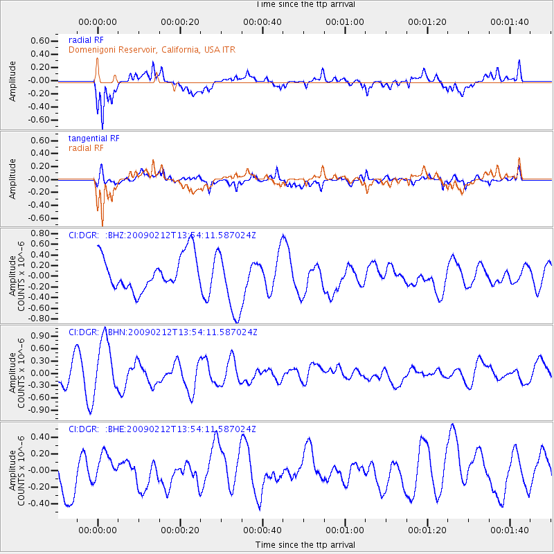
DGR Domenigoni Reservoir, California, USA - Earthquake Result Viewer
*The percent match for this event was below the threshold and hence no stack was calculated.
| Earthquake location: |
South Of Mariana Islands |
| Earthquake latitude/longitude: |
12.1/143.8 |
| Earthquake time(UTC): |
2009/02/12 (043) 13:41:43 GMT |
| Earthquake Depth: |
40 km |
| Earthquake Magnitude: |
5.5 MB |
| Earthquake Catalog/Contributor: |
WHDF/NEIC |
|
| Network: |
CI Caltech Regional Seismic Network |
| Station: |
DGR Domenigoni Reservoir, California, USA |
| Lat/Lon: |
33.65 N/117.01 W |
| Elevation: |
609 m |
|
| Distance: |
90.9 deg |
| Az: |
55.433 deg |
| Baz: |
285.123 deg |
| Ray Param: |
$rayparam |
*The percent match for this event was below the threshold and hence was not used in the summary stack. |
|
| Radial Match: |
75.00817 % |
| Radial Bump: |
400 |
| Transverse Match: |
61.56515 % |
| Transverse Bump: |
400 |
| SOD ConfigId: |
2658 |
| Insert Time: |
2010-03-05 21:39:00.659 +0000 |
| GWidth: |
2.5 |
| Max Bumps: |
400 |
| Tol: |
0.001 |
|
Signal To Noise
| Channel | StoN | STA | LTA |
| CI:DGR: :BHN:20090212T13:54:11.587024Z | 2.4134197 | 6.670428E-7 | 2.7638907E-7 |
| CI:DGR: :BHE:20090212T13:54:11.587024Z | 0.81670624 | 1.7290503E-7 | 2.1171019E-7 |
| CI:DGR: :BHZ:20090212T13:54:11.587024Z | 1.9345155 | 6.116609E-7 | 3.16183E-7 |
| Arrivals |
| Ps | |
| PpPs | |
| PsPs/PpSs | |


