You are here: Home > Network List > CI - Caltech Regional Seismic Network Stations List
> Station DGR Domenigoni Reservoir, California, USA > Earthquake Result Viewer
DGR Domenigoni Reservoir, California, USA - Earthquake Result Viewer
*The percent match for this event was below the threshold and hence no stack was calculated.
| Earthquake location: |
South Of Kermadec Islands |
| Earthquake latitude/longitude: |
-33.5/-179.5 |
| Earthquake time(UTC): |
1998/04/10 (100) 16:43:41 GMT |
| Earthquake Depth: |
46 km |
| Earthquake Magnitude: |
5.9 MB, 5.9 MS, 6.0 UNKNOWN, 6.0 MW |
| Earthquake Catalog/Contributor: |
WHDF/NEIC |
|
| Network: |
CI Caltech Regional Seismic Network |
| Station: |
DGR Domenigoni Reservoir, California, USA |
| Lat/Lon: |
33.65 N/117.01 W |
| Elevation: |
609 m |
|
| Distance: |
89.0 deg |
| Az: |
47.752 deg |
| Baz: |
227.828 deg |
| Ray Param: |
$rayparam |
*The percent match for this event was below the threshold and hence was not used in the summary stack. |
|
| Radial Match: |
68.561165 % |
| Radial Bump: |
400 |
| Transverse Match: |
73.08736 % |
| Transverse Bump: |
400 |
| SOD ConfigId: |
4480 |
| Insert Time: |
2010-03-05 21:39:09.354 +0000 |
| GWidth: |
2.5 |
| Max Bumps: |
400 |
| Tol: |
0.001 |
|
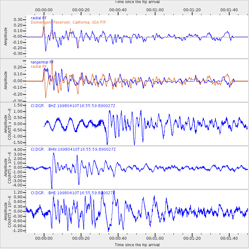
Signal To Noise
| Channel | StoN | STA | LTA |
| CI:DGR: :BHN:19980410T16:55:59.890027Z | 7.4005065 | 1.4244927E-6 | 1.9248583E-7 |
| CI:DGR: :BHE:19980410T16:55:59.890027Z | 1.5476149 | 3.4443875E-7 | 2.2256103E-7 |
| CI:DGR: :BHZ:19980410T16:55:59.890027Z | 1.9705285 | 5.7770666E-7 | 2.9317349E-7 |
| Arrivals |
| Ps | |
| PpPs | |
| PsPs/PpSs | |


