You are here: Home > Network List > CI - Caltech Regional Seismic Network Stations List
> Station DGR Domenigoni Reservoir, California, USA > Earthquake Result Viewer
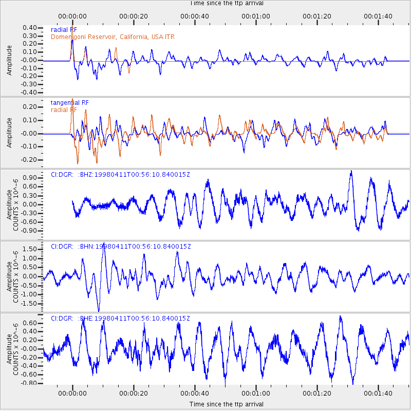
DGR Domenigoni Reservoir, California, USA - Earthquake Result Viewer
*The percent match for this event was below the threshold and hence no stack was calculated.
| Earthquake location: |
South Of Fiji Islands |
| Earthquake latitude/longitude: |
-23.6/-176.1 |
| Earthquake time(UTC): |
1998/04/11 (101) 00:44:35 GMT |
| Earthquake Depth: |
33 km |
| Earthquake Magnitude: |
5.7 MB, 6.1 MS, 6.2 UNKNOWN, 6.1 MW |
| Earthquake Catalog/Contributor: |
WHDF/NEIC |
|
| Network: |
CI Caltech Regional Seismic Network |
| Station: |
DGR Domenigoni Reservoir, California, USA |
| Lat/Lon: |
33.65 N/117.01 W |
| Elevation: |
609 m |
|
| Distance: |
80.0 deg |
| Az: |
46.612 deg |
| Baz: |
233.034 deg |
| Ray Param: |
$rayparam |
*The percent match for this event was below the threshold and hence was not used in the summary stack. |
|
| Radial Match: |
70.41996 % |
| Radial Bump: |
392 |
| Transverse Match: |
42.004772 % |
| Transverse Bump: |
363 |
| SOD ConfigId: |
4480 |
| Insert Time: |
2010-03-05 21:39:13.363 +0000 |
| GWidth: |
2.5 |
| Max Bumps: |
400 |
| Tol: |
0.001 |
|
Signal To Noise
| Channel | StoN | STA | LTA |
| CI:DGR: :BHN:19980411T00:56:10.840015Z | 1.2692556 | 4.2035137E-7 | 3.3117945E-7 |
| CI:DGR: :BHE:19980411T00:56:10.840015Z | 1.332159 | 3.4420577E-7 | 2.583819E-7 |
| CI:DGR: :BHZ:19980411T00:56:10.840015Z | 2.6242137 | 3.7864066E-7 | 1.4428728E-7 |
| Arrivals |
| Ps | |
| PpPs | |
| PsPs/PpSs | |


