You are here: Home > Network List > CI - Caltech Regional Seismic Network Stations List
> Station DGR Domenigoni Reservoir, California, USA > Earthquake Result Viewer
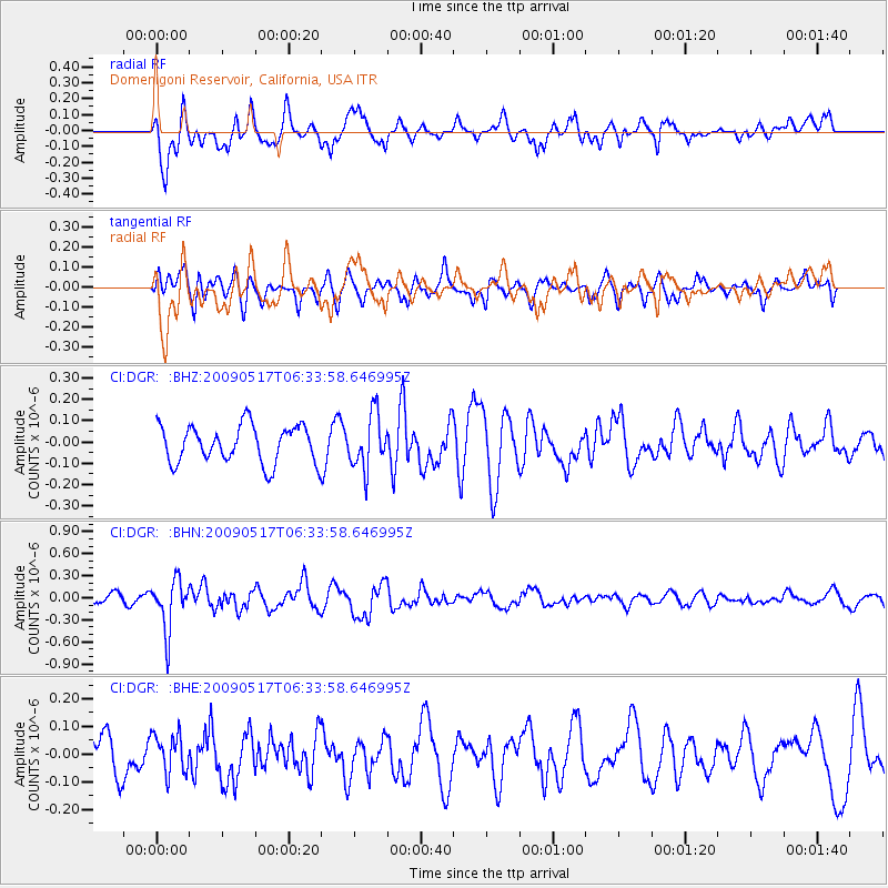
DGR Domenigoni Reservoir, California, USA - Earthquake Result Viewer
*The percent match for this event was below the threshold and hence no stack was calculated.
| Earthquake location: |
Tonga Islands |
| Earthquake latitude/longitude: |
-16.8/-173.5 |
| Earthquake time(UTC): |
2009/05/17 (137) 06:23:03 GMT |
| Earthquake Depth: |
67 km |
| Earthquake Magnitude: |
5.5 MB, 5.6 MW, 5.6 MW |
| Earthquake Catalog/Contributor: |
WHDF/NEIC |
|
| Network: |
CI Caltech Regional Seismic Network |
| Station: |
DGR Domenigoni Reservoir, California, USA |
| Lat/Lon: |
33.65 N/117.01 W |
| Elevation: |
609 m |
|
| Distance: |
73.6 deg |
| Az: |
46.466 deg |
| Baz: |
236.343 deg |
| Ray Param: |
$rayparam |
*The percent match for this event was below the threshold and hence was not used in the summary stack. |
|
| Radial Match: |
59.620693 % |
| Radial Bump: |
400 |
| Transverse Match: |
53.522427 % |
| Transverse Bump: |
400 |
| SOD ConfigId: |
2760 |
| Insert Time: |
2010-03-05 21:39:17.681 +0000 |
| GWidth: |
2.5 |
| Max Bumps: |
400 |
| Tol: |
0.001 |
|
Signal To Noise
| Channel | StoN | STA | LTA |
| CI:DGR: :BHN:20090517T06:33:58.646995Z | 3.3259196 | 3.4527423E-7 | 1.0381316E-7 |
| CI:DGR: :BHE:20090517T06:33:58.646995Z | 1.1506138 | 6.974794E-8 | 6.061803E-8 |
| CI:DGR: :BHZ:20090517T06:33:58.646995Z | 1.4519645 | 1.2723173E-7 | 8.76273E-8 |
| Arrivals |
| Ps | |
| PpPs | |
| PsPs/PpSs | |


