You are here: Home > Network List > CI - Caltech Regional Seismic Network Stations List
> Station DGR Domenigoni Reservoir, California, USA > Earthquake Result Viewer
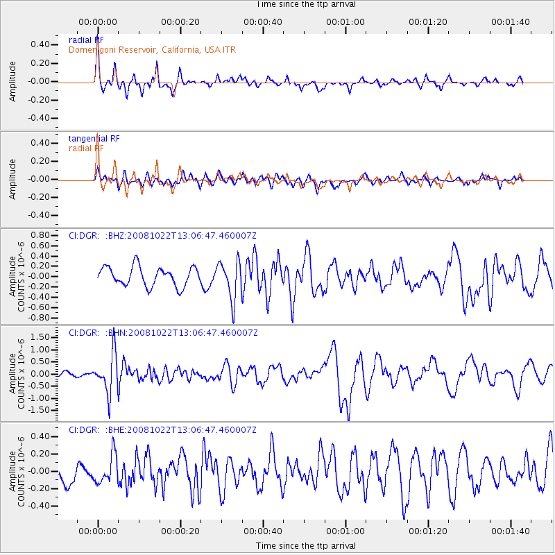
DGR Domenigoni Reservoir, California, USA - Earthquake Result Viewer
*The percent match for this event was below the threshold and hence no stack was calculated.
| Earthquake location: |
Tonga Islands |
| Earthquake latitude/longitude: |
-18.4/-175.4 |
| Earthquake time(UTC): |
2008/10/22 (296) 12:55:57 GMT |
| Earthquake Depth: |
233 km |
| Earthquake Magnitude: |
5.9 MB, 6.4 MW, 6.3 MW |
| Earthquake Catalog/Contributor: |
WHDF/NEIC |
|
| Network: |
CI Caltech Regional Seismic Network |
| Station: |
DGR Domenigoni Reservoir, California, USA |
| Lat/Lon: |
33.65 N/117.01 W |
| Elevation: |
609 m |
|
| Distance: |
76.0 deg |
| Az: |
47.043 deg |
| Baz: |
236.409 deg |
| Ray Param: |
$rayparam |
*The percent match for this event was below the threshold and hence was not used in the summary stack. |
|
| Radial Match: |
76.4349 % |
| Radial Bump: |
319 |
| Transverse Match: |
60.409603 % |
| Transverse Bump: |
400 |
| SOD ConfigId: |
2556 |
| Insert Time: |
2010-03-05 21:39:44.734 +0000 |
| GWidth: |
2.5 |
| Max Bumps: |
400 |
| Tol: |
0.001 |
|
Signal To Noise
| Channel | StoN | STA | LTA |
| CI:DGR: :BHN:20081022T13:06:47.460007Z | 4.4524264 | 8.3351574E-7 | 1.8720483E-7 |
| CI:DGR: :BHE:20081022T13:06:47.460007Z | 1.3446646 | 1.7132609E-7 | 1.2741178E-7 |
| CI:DGR: :BHZ:20081022T13:06:47.460007Z | 2.0691264 | 3.8279634E-7 | 1.8500386E-7 |
| Arrivals |
| Ps | |
| PpPs | |
| PsPs/PpSs | |


