You are here: Home > Network List > TA - USArray Transportable Network (new EarthScope stations) Stations List
> Station A21K Barrow, AK, USA > Earthquake Result Viewer
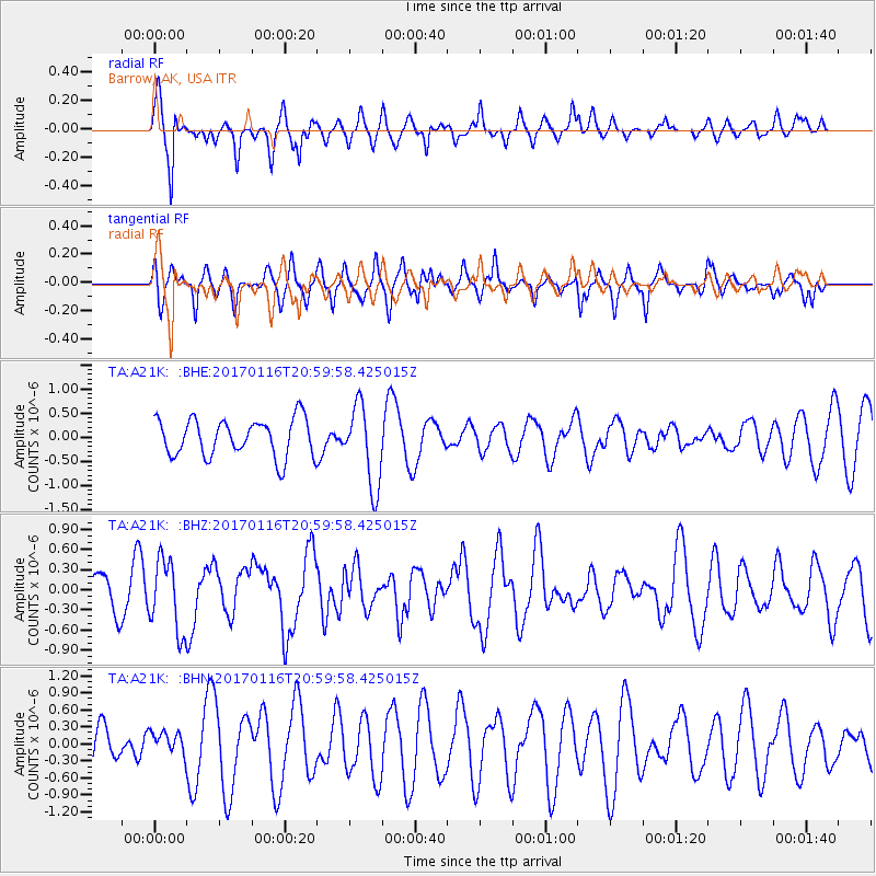
A21K Barrow, AK, USA - Earthquake Result Viewer
*The percent match for this event was below the threshold and hence no stack was calculated.
| Earthquake location: |
Vanuatu Islands |
| Earthquake latitude/longitude: |
-13.5/166.5 |
| Earthquake time(UTC): |
2017/01/16 (016) 20:47:38 GMT |
| Earthquake Depth: |
10 km |
| Earthquake Magnitude: |
5.7 Mwb |
| Earthquake Catalog/Contributor: |
NEIC PDE/us |
|
| Network: |
TA USArray Transportable Network (new EarthScope stations) |
| Station: |
A21K Barrow, AK, USA |
| Lat/Lon: |
71.32 N/156.62 W |
| Elevation: |
577 m |
|
| Distance: |
88.2 deg |
| Az: |
11.163 deg |
| Baz: |
215.775 deg |
| Ray Param: |
$rayparam |
*The percent match for this event was below the threshold and hence was not used in the summary stack. |
|
| Radial Match: |
55.460503 % |
| Radial Bump: |
386 |
| Transverse Match: |
51.872192 % |
| Transverse Bump: |
356 |
| SOD ConfigId: |
11737051 |
| Insert Time: |
2019-04-26 15:46:56.142 +0000 |
| GWidth: |
2.5 |
| Max Bumps: |
400 |
| Tol: |
0.001 |
|
Signal To Noise
| Channel | StoN | STA | LTA |
| TA:A21K: :BHZ:20170116T20:59:58.425015Z | 2.03192 | 5.387929E-7 | 2.6516446E-7 |
| TA:A21K: :BHN:20170116T20:59:58.425015Z | 0.8468513 | 2.0824119E-7 | 2.4590054E-7 |
| TA:A21K: :BHE:20170116T20:59:58.425015Z | 2.1712546 | 8.375531E-7 | 3.8574612E-7 |
| Arrivals |
| Ps | |
| PpPs | |
| PsPs/PpSs | |


