You are here: Home > Network List > IU - Global Seismograph Network (GSN - IRIS/USGS) Stations List
> Station KMBO Kilima Mbogo, Kenya > Earthquake Result Viewer
KMBO Kilima Mbogo, Kenya - Earthquake Result Viewer
| Earthquake location: |
Nicobar Islands, India Region |
| Earthquake latitude/longitude: |
6.8/94.7 |
| Earthquake time(UTC): |
2015/11/08 (312) 16:47:01 GMT |
| Earthquake Depth: |
7.7 km |
| Earthquake Magnitude: |
6.4 MWB |
| Earthquake Catalog/Contributor: |
NEIC PDE/NEIC COMCAT |
|
| Network: |
IU Global Seismograph Network (GSN - IRIS/USGS) |
| Station: |
KMBO Kilima Mbogo, Kenya |
| Lat/Lon: |
1.13 S/37.25 E |
| Elevation: |
1950 m |
|
| Distance: |
57.9 deg |
| Az: |
264.377 deg |
| Baz: |
81.261 deg |
| Ray Param: |
0.06320615 |
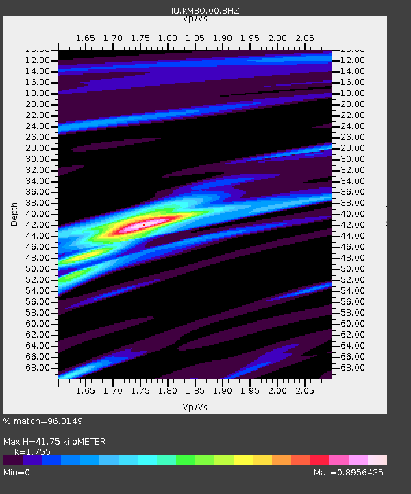
| Estimated Moho Depth: |
41.75 km |
| Estimated Crust Vp/Vs: |
1.75 |
| Assumed Crust Vp: |
6.601 km/s |
| Estimated Crust Vs: |
3.761 km/s |
| Estimated Crust Poisson's Ratio: |
0.26 |
|
| Radial Match: |
96.8149 % |
| Radial Bump: |
263 |
| Transverse Match: |
85.88621 % |
| Transverse Bump: |
400 |
| SOD ConfigId: |
1259291 |
| Insert Time: |
2015-11-22 17:02:18.720 +0000 |
| GWidth: |
2.5 |
| Max Bumps: |
400 |
| Tol: |
0.001 |
|

Signal To Noise
| Channel | StoN | STA | LTA |
| IU:KMBO:00:BHZ:20151108T16:56:22.91897Z | 6.265442 | 4.3987063E-7 | 7.020584E-8 |
| IU:KMBO:00:BH1:20151108T16:56:22.91897Z | 1.4908307 | 1.0207921E-7 | 6.8471365E-8 |
| IU:KMBO:00:BH2:20151108T16:56:22.91897Z | 3.157338 | 1.8606137E-7 | 5.8929825E-8 |
| Arrivals |
| Ps | 5.0 SECOND |
| PpPs | 17 SECOND |
| PsPs/PpSs | 22 SECOND |


