You are here: Home > Network List > CI - Caltech Regional Seismic Network Stations List
> Station DAN DAN, Needles, CA, USA > Earthquake Result Viewer
DAN DAN, Needles, CA, USA - Earthquake Result Viewer
| Earthquake location: |
Mariana Islands Region |
| Earthquake latitude/longitude: |
21.6/143.0 |
| Earthquake time(UTC): |
2001/07/03 (184) 13:10:42 GMT |
| Earthquake Depth: |
290 km |
| Earthquake Magnitude: |
6.0 MB, 6.5 MW, 6.5 MW |
| Earthquake Catalog/Contributor: |
WHDF/NEIC |
|
| Network: |
CI Caltech Regional Seismic Network |
| Station: |
DAN DAN, Needles, CA, USA |
| Lat/Lon: |
34.64 N/115.38 W |
| Elevation: |
428 m |
|
| Distance: |
87.0 deg |
| Az: |
53.972 deg |
| Baz: |
294.145 deg |
| Ray Param: |
0.042945776 |
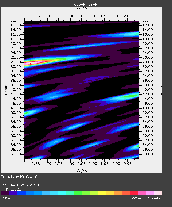
| Estimated Moho Depth: |
28.25 km |
| Estimated Crust Vp/Vs: |
1.62 |
| Assumed Crust Vp: |
6.276 km/s |
| Estimated Crust Vs: |
3.862 km/s |
| Estimated Crust Poisson's Ratio: |
0.20 |
|
| Radial Match: |
93.87178 % |
| Radial Bump: |
356 |
| Transverse Match: |
89.63999 % |
| Transverse Bump: |
400 |
| SOD ConfigId: |
3787 |
| Insert Time: |
2010-02-26 01:00:50.023 +0000 |
| GWidth: |
2.5 |
| Max Bumps: |
400 |
| Tol: |
0.001 |
|
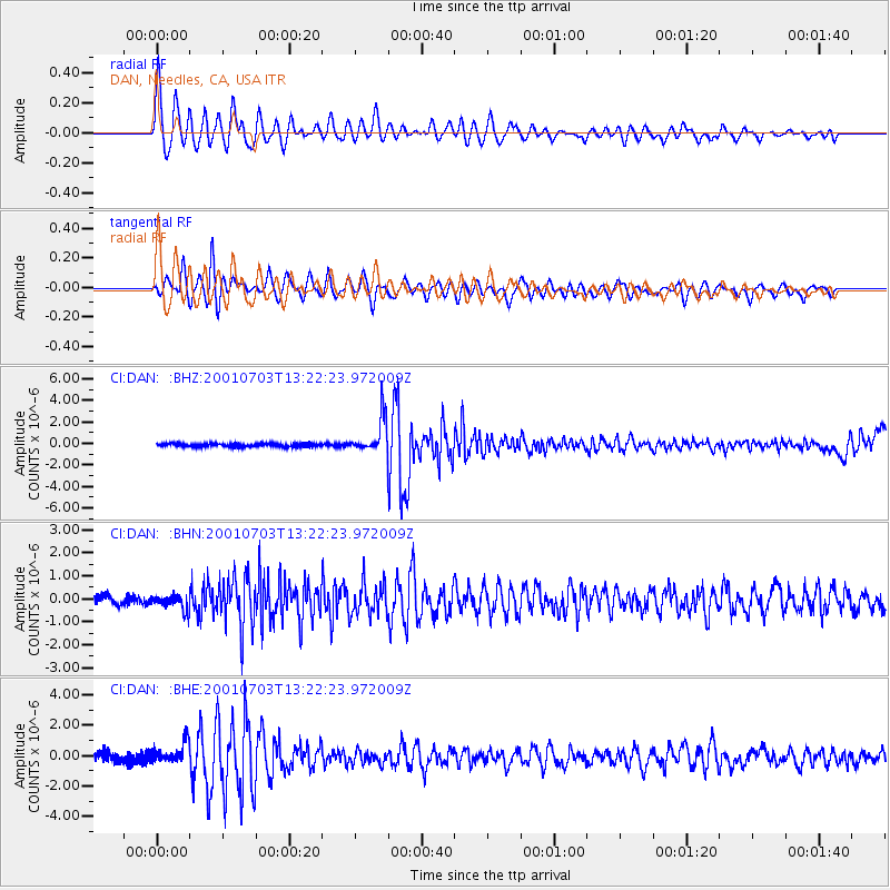
Signal To Noise
| Channel | StoN | STA | LTA |
| CI:DAN: :BHN:20010703T13:22:23.972009Z | 1.8182335 | 3.2854757E-7 | 1.8069603E-7 |
| CI:DAN: :BHE:20010703T13:22:23.972009Z | 2.878894 | 6.629618E-7 | 2.3028348E-7 |
| CI:DAN: :BHZ:20010703T13:22:23.972009Z | 10.745439 | 1.646467E-6 | 1.5322475E-7 |
| Arrivals |
| Ps | 2.9 SECOND |
| PpPs | 12 SECOND |
| PsPs/PpSs | 14 SECOND |


