You are here: Home > Network List > CI - Caltech Regional Seismic Network Stations List
> Station DGR Domenigoni Reservoir, California, USA > Earthquake Result Viewer
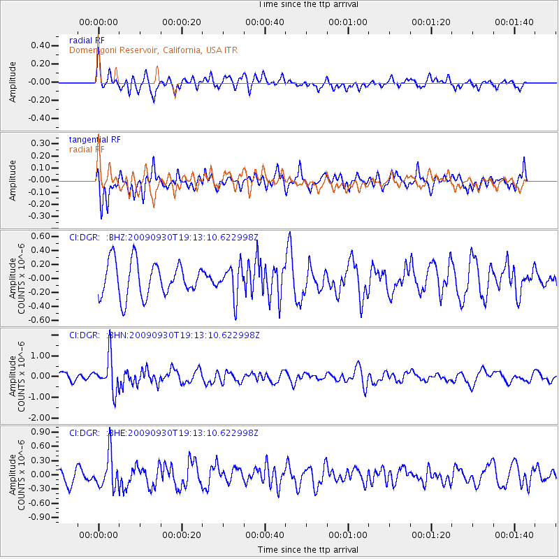
DGR Domenigoni Reservoir, California, USA - Earthquake Result Viewer
*The percent match for this event was below the threshold and hence no stack was calculated.
| Earthquake location: |
Peru-Bolivia Border Region |
| Earthquake latitude/longitude: |
-15.6/-69.3 |
| Earthquake time(UTC): |
2009/09/30 (273) 19:03:17 GMT |
| Earthquake Depth: |
255 km |
| Earthquake Magnitude: |
5.9 MB, 5.8 MW |
| Earthquake Catalog/Contributor: |
WHDF/NEIC |
|
| Network: |
CI Caltech Regional Seismic Network |
| Station: |
DGR Domenigoni Reservoir, California, USA |
| Lat/Lon: |
33.65 N/117.01 W |
| Elevation: |
609 m |
|
| Distance: |
66.8 deg |
| Az: |
317.822 deg |
| Baz: |
129.119 deg |
| Ray Param: |
$rayparam |
*The percent match for this event was below the threshold and hence was not used in the summary stack. |
|
| Radial Match: |
60.08215 % |
| Radial Bump: |
400 |
| Transverse Match: |
63.617798 % |
| Transverse Bump: |
400 |
| SOD ConfigId: |
2622 |
| Insert Time: |
2010-03-05 21:40:09.120 +0000 |
| GWidth: |
2.5 |
| Max Bumps: |
400 |
| Tol: |
0.001 |
|
Signal To Noise
| Channel | StoN | STA | LTA |
| CI:DGR: :BHN:20090930T19:13:10.622998Z | 4.8860765 | 8.6551677E-7 | 1.7713941E-7 |
| CI:DGR: :BHE:20090930T19:13:10.622998Z | 2.6396103 | 3.6578226E-7 | 1.3857435E-7 |
| CI:DGR: :BHZ:20090930T19:13:10.622998Z | 0.92594314 | 2.2764547E-7 | 2.4585253E-7 |
| Arrivals |
| Ps | |
| PpPs | |
| PsPs/PpSs | |


