You are here: Home > Network List > IU - Global Seismograph Network (GSN - IRIS/USGS) Stations List
> Station MAKZ Makanchi, Kazakhstan > Earthquake Result Viewer
MAKZ Makanchi, Kazakhstan - Earthquake Result Viewer

| Earthquake location: |
Nicobar Islands, India Region |
| Earthquake latitude/longitude: |
6.8/94.7 |
| Earthquake time(UTC): |
2015/11/08 (312) 16:47:01 GMT |
| Earthquake Depth: |
7.7 km |
| Earthquake Magnitude: |
6.4 MWB |
| Earthquake Catalog/Contributor: |
NEIC PDE/NEIC COMCAT |
|
| Network: |
IU Global Seismograph Network (GSN - IRIS/USGS) |
| Station: |
MAKZ Makanchi, Kazakhstan |
| Lat/Lon: |
46.81 N/81.98 E |
| Elevation: |
600 m |
|
| Distance: |
41.3 deg |
| Az: |
346.725 deg |
| Baz: |
160.613 deg |
| Ray Param: |
0.07388253 |
| Estimated Moho Depth: |
43.0 km |
| Estimated Crust Vp/Vs: |
1.89 |
| Assumed Crust Vp: |
6.571 km/s |
| Estimated Crust Vs: |
3.477 km/s |
| Estimated Crust Poisson's Ratio: |
0.31 |
|
| Radial Match: |
96.37979 % |
| Radial Bump: |
376 |
| Transverse Match: |
78.03125 % |
| Transverse Bump: |
400 |
| SOD ConfigId: |
1259291 |
| Insert Time: |
2015-11-22 17:02:23.742 +0000 |
| GWidth: |
2.5 |
| Max Bumps: |
400 |
| Tol: |
0.001 |
|
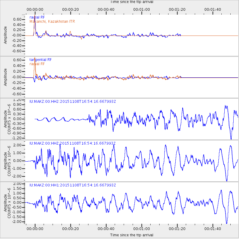
Signal To Noise
| Channel | StoN | STA | LTA |
| IU:MAKZ:00:HHZ:20151108T16:54:16.667993Z | 6.2316413 | 5.6290355E-7 | 9.0329905E-8 |
| IU:MAKZ:00:HH1:20151108T16:54:16.667993Z | 5.8241053 | 2.734407E-7 | 4.694982E-8 |
| IU:MAKZ:00:HH2:20151108T16:54:16.667993Z | 2.214786 | 1.479339E-7 | 6.679377E-8 |
| Arrivals |
| Ps | 6.2 SECOND |
| PpPs | 18 SECOND |
| PsPs/PpSs | 24 SECOND |


