You are here: Home > Network List > CI - Caltech Regional Seismic Network Stations List
> Station DGR Domenigoni Reservoir, California, USA > Earthquake Result Viewer
DGR Domenigoni Reservoir, California, USA - Earthquake Result Viewer
*The percent match for this event was below the threshold and hence no stack was calculated.
| Earthquake location: |
Mariana Islands |
| Earthquake latitude/longitude: |
19.1/145.8 |
| Earthquake time(UTC): |
2008/12/02 (337) 12:31:43 GMT |
| Earthquake Depth: |
137 km |
| Earthquake Magnitude: |
5.9 MB, 5.9 MW, 5.9 MW |
| Earthquake Catalog/Contributor: |
WHDF/NEIC |
|
| Network: |
CI Caltech Regional Seismic Network |
| Station: |
DGR Domenigoni Reservoir, California, USA |
| Lat/Lon: |
33.65 N/117.01 W |
| Elevation: |
609 m |
|
| Distance: |
85.4 deg |
| Az: |
56.115 deg |
| Baz: |
289.77 deg |
| Ray Param: |
$rayparam |
*The percent match for this event was below the threshold and hence was not used in the summary stack. |
|
| Radial Match: |
49.8739 % |
| Radial Bump: |
400 |
| Transverse Match: |
77.04026 % |
| Transverse Bump: |
330 |
| SOD ConfigId: |
2658 |
| Insert Time: |
2010-03-05 21:40:44.988 +0000 |
| GWidth: |
2.5 |
| Max Bumps: |
400 |
| Tol: |
0.001 |
|
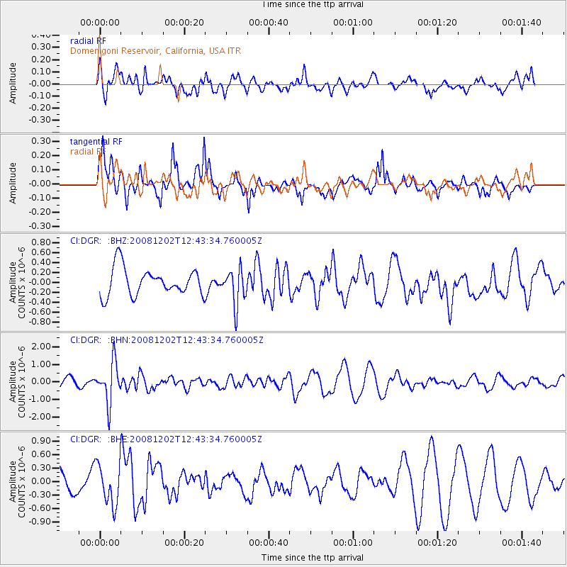
Signal To Noise
| Channel | StoN | STA | LTA |
| CI:DGR: :BHN:20081202T12:43:34.760005Z | 3.8375058 | 1.1767987E-6 | 3.0665717E-7 |
| CI:DGR: :BHE:20081202T12:43:34.760005Z | 1.0753827 | 4.501148E-7 | 4.1856242E-7 |
| CI:DGR: :BHZ:20081202T12:43:34.760005Z | 1.3454174 | 3.7013183E-7 | 2.7510558E-7 |
| Arrivals |
| Ps | |
| PpPs | |
| PsPs/PpSs | |


