You are here: Home > Network List > AK - Alaska Regional Network Stations List
> Station SAMH Samovar Hills, AK, USA > Earthquake Result Viewer
SAMH Samovar Hills, AK, USA - Earthquake Result Viewer
| Earthquake location: |
Solomon Islands |
| Earthquake latitude/longitude: |
-10.4/161.3 |
| Earthquake time(UTC): |
2017/01/19 (019) 23:04:20 GMT |
| Earthquake Depth: |
34 km |
| Earthquake Magnitude: |
6.8 mwp |
| Earthquake Catalog/Contributor: |
NEIC PDE/us |
|
| Network: |
AK Alaska Regional Network |
| Station: |
SAMH Samovar Hills, AK, USA |
| Lat/Lon: |
60.13 N/140.78 W |
| Elevation: |
1140 m |
|
| Distance: |
83.9 deg |
| Az: |
25.256 deg |
| Baz: |
237.0 deg |
| Ray Param: |
0.045840576 |
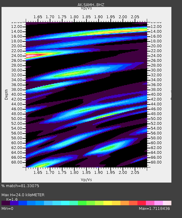
| Estimated Moho Depth: |
24.0 km |
| Estimated Crust Vp/Vs: |
1.60 |
| Assumed Crust Vp: |
6.566 km/s |
| Estimated Crust Vs: |
4.104 km/s |
| Estimated Crust Poisson's Ratio: |
0.18 |
|
| Radial Match: |
81.33075 % |
| Radial Bump: |
365 |
| Transverse Match: |
84.560555 % |
| Transverse Bump: |
357 |
| SOD ConfigId: |
11737051 |
| Insert Time: |
2019-04-26 16:07:36.068 +0000 |
| GWidth: |
2.5 |
| Max Bumps: |
400 |
| Tol: |
0.001 |
|

Signal To Noise
| Channel | StoN | STA | LTA |
| AK:SAMH: :BHZ:20170119T23:16:15.808008Z | 7.2042046 | 5.045969E-6 | 7.0042E-7 |
| AK:SAMH: :BHN:20170119T23:16:15.808008Z | 3.400064 | 2.7043193E-6 | 7.95373E-7 |
| AK:SAMH: :BHE:20170119T23:16:15.808008Z | 2.9416003 | 2.0787054E-6 | 7.06658E-7 |
| Arrivals |
| Ps | 2.3 SECOND |
| PpPs | 9.2 SECOND |
| PsPs/PpSs | 11 SECOND |


