You are here: Home > Network List > CI - Caltech Regional Seismic Network Stations List
> Station DGR Domenigoni Reservoir, California, USA > Earthquake Result Viewer
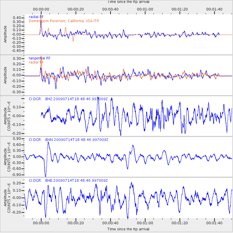
DGR Domenigoni Reservoir, California, USA - Earthquake Result Viewer
*The percent match for this event was below the threshold and hence no stack was calculated.
| Earthquake location: |
Chile-Bolivia Border Region |
| Earthquake latitude/longitude: |
-21.8/-67.1 |
| Earthquake time(UTC): |
2009/07/14 (195) 18:38:08 GMT |
| Earthquake Depth: |
176 km |
| Earthquake Magnitude: |
5.7 MW, 5.4 MB, 5.7 MW |
| Earthquake Catalog/Contributor: |
WHDF/NEIC |
|
| Network: |
CI Caltech Regional Seismic Network |
| Station: |
DGR Domenigoni Reservoir, California, USA |
| Lat/Lon: |
33.65 N/117.01 W |
| Elevation: |
609 m |
|
| Distance: |
72.8 deg |
| Az: |
318.084 deg |
| Baz: |
131.913 deg |
| Ray Param: |
$rayparam |
*The percent match for this event was below the threshold and hence was not used in the summary stack. |
|
| Radial Match: |
63.39189 % |
| Radial Bump: |
400 |
| Transverse Match: |
75.15009 % |
| Transverse Bump: |
400 |
| SOD ConfigId: |
2648 |
| Insert Time: |
2010-03-05 21:41:31.416 +0000 |
| GWidth: |
2.5 |
| Max Bumps: |
400 |
| Tol: |
0.001 |
|
Signal To Noise
| Channel | StoN | STA | LTA |
| CI:DGR: :BHN:20090714T18:48:46.997009Z | 4.2756796 | 4.738097E-7 | 1.10815066E-7 |
| CI:DGR: :BHE:20090714T18:48:46.997009Z | 1.9469539 | 1.2326409E-7 | 6.331125E-8 |
| CI:DGR: :BHZ:20090714T18:48:46.997009Z | 2.3377569 | 1.1183437E-7 | 4.7838324E-8 |
| Arrivals |
| Ps | |
| PpPs | |
| PsPs/PpSs | |


