You are here: Home > Network List > AT - Alaska Tsunami Warning Seismic System Stations List
> Station SVW2 Sparrevohn, Alaska > Earthquake Result Viewer
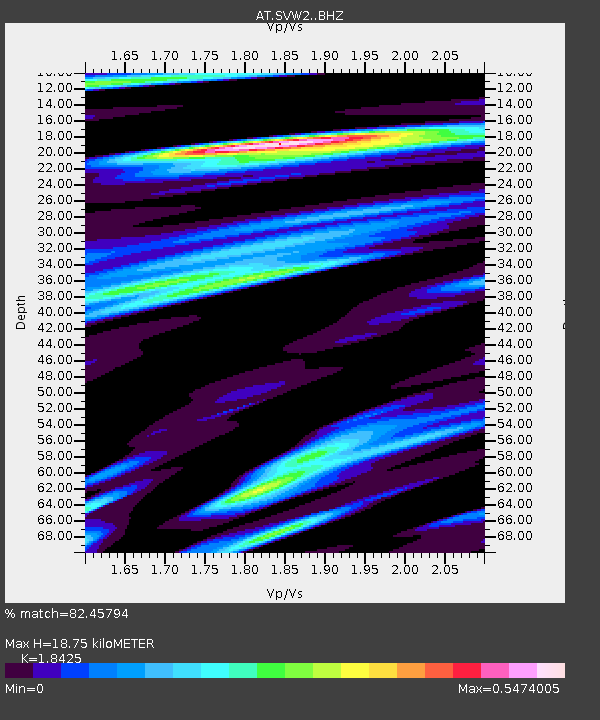
SVW2 Sparrevohn, Alaska - Earthquake Result Viewer
| Earthquake location: |
Solomon Islands |
| Earthquake latitude/longitude: |
-10.4/161.3 |
| Earthquake time(UTC): |
2017/01/19 (019) 23:04:20 GMT |
| Earthquake Depth: |
34 km |
| Earthquake Magnitude: |
6.8 mwp |
| Earthquake Catalog/Contributor: |
NEIC PDE/us |
|
| Network: |
AT Alaska Tsunami Warning Seismic System |
| Station: |
SVW2 Sparrevohn, Alaska |
| Lat/Lon: |
61.11 N/155.62 W |
| Elevation: |
499 m |
|
| Distance: |
78.9 deg |
| Az: |
19.766 deg |
| Baz: |
223.247 deg |
| Ray Param: |
0.049295656 |
| Estimated Moho Depth: |
18.75 km |
| Estimated Crust Vp/Vs: |
1.84 |
| Assumed Crust Vp: |
6.566 km/s |
| Estimated Crust Vs: |
3.564 km/s |
| Estimated Crust Poisson's Ratio: |
0.29 |
|
| Radial Match: |
82.45794 % |
| Radial Bump: |
238 |
| Transverse Match: |
74.64755 % |
| Transverse Bump: |
400 |
| SOD ConfigId: |
11737051 |
| Insert Time: |
2019-04-26 16:07:59.764 +0000 |
| GWidth: |
2.5 |
| Max Bumps: |
400 |
| Tol: |
0.001 |
|

Signal To Noise
| Channel | StoN | STA | LTA |
| AT:SVW2: :BHZ:20170119T23:15:49.519983Z | 13.77142 | 4.043816E-6 | 2.9363827E-7 |
| AT:SVW2: :BHN:20170119T23:15:49.519983Z | 6.276264 | 1.8786013E-6 | 2.993184E-7 |
| AT:SVW2: :BHE:20170119T23:15:49.519983Z | 2.0544033 | 6.617211E-7 | 3.2209894E-7 |
| Arrivals |
| Ps | 2.5 SECOND |
| PpPs | 7.9 SECOND |
| PsPs/PpSs | 10 SECOND |


