You are here: Home > Network List > CB - China National Seismic Network Stations List
> Station HHC Huhehaote,Neimeng Province > Earthquake Result Viewer
HHC Huhehaote,Neimeng Province - Earthquake Result Viewer
| Earthquake location: |
Solomon Islands |
| Earthquake latitude/longitude: |
-10.4/161.3 |
| Earthquake time(UTC): |
2017/01/19 (019) 23:04:20 GMT |
| Earthquake Depth: |
34 km |
| Earthquake Magnitude: |
6.8 mwp |
| Earthquake Catalog/Contributor: |
NEIC PDE/us |
|
| Network: |
CB China National Seismic Network |
| Station: |
HHC Huhehaote,Neimeng Province |
| Lat/Lon: |
40.85 N/111.56 E |
| Elevation: |
1169 m |
|
| Distance: |
68.5 deg |
| Az: |
321.544 deg |
| Baz: |
126.229 deg |
| Ray Param: |
0.056203343 |
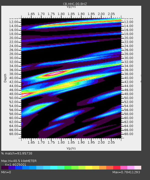
| Estimated Moho Depth: |
48.5 km |
| Estimated Crust Vp/Vs: |
1.60 |
| Assumed Crust Vp: |
6.384 km/s |
| Estimated Crust Vs: |
3.984 km/s |
| Estimated Crust Poisson's Ratio: |
0.18 |
|
| Radial Match: |
93.95738 % |
| Radial Bump: |
297 |
| Transverse Match: |
83.729744 % |
| Transverse Bump: |
400 |
| SOD ConfigId: |
11737051 |
| Insert Time: |
2019-04-26 16:09:53.941 +0000 |
| GWidth: |
2.5 |
| Max Bumps: |
400 |
| Tol: |
0.001 |
|

Signal To Noise
| Channel | StoN | STA | LTA |
| CB:HHC:00:BHZ:20170119T23:14:49.11001Z | 20.694637 | 2.4925503E-6 | 1.2044426E-7 |
| CB:HHC:00:BHN:20170119T23:14:49.11001Z | 6.17169 | 6.307062E-7 | 1.0219343E-7 |
| CB:HHC:00:BHE:20170119T23:14:49.11001Z | 7.2141075 | 8.4428734E-7 | 1.1703282E-7 |
| Arrivals |
| Ps | 4.8 SECOND |
| PpPs | 19 SECOND |
| PsPs/PpSs | 24 SECOND |


