You are here: Home > Network List > PS - Pacific21 Stations List
> Station PSI Parapat, Indonesia > Earthquake Result Viewer
PSI Parapat, Indonesia - Earthquake Result Viewer
| Earthquake location: |
Solomon Islands |
| Earthquake latitude/longitude: |
-10.4/161.3 |
| Earthquake time(UTC): |
2017/01/19 (019) 23:04:20 GMT |
| Earthquake Depth: |
34 km |
| Earthquake Magnitude: |
6.8 mwp |
| Earthquake Catalog/Contributor: |
NEIC PDE/us |
|
| Network: |
PS Pacific21 |
| Station: |
PSI Parapat, Indonesia |
| Lat/Lon: |
2.69 N/98.92 E |
| Elevation: |
987 m |
|
| Distance: |
63.4 deg |
| Az: |
278.273 deg |
| Baz: |
102.9 deg |
| Ray Param: |
0.05954393 |
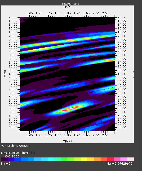
| Estimated Moho Depth: |
58.0 km |
| Estimated Crust Vp/Vs: |
1.86 |
| Assumed Crust Vp: |
6.468 km/s |
| Estimated Crust Vs: |
3.473 km/s |
| Estimated Crust Poisson's Ratio: |
0.30 |
|
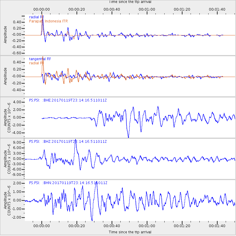
| Radial Match: |
97.08284 % |
| Radial Bump: |
400 |
| Transverse Match: |
95.12924 % |
| Transverse Bump: |
400 |
| SOD ConfigId: |
11737051 |
| Insert Time: |
2019-04-26 16:13:44.126 +0000 |
| GWidth: |
2.5 |
| Max Bumps: |
400 |
| Tol: |
0.001 |
|
Signal To Noise
| Channel | StoN | STA | LTA |
| PS:PSI: :BHZ:20170119T23:14:16.511011Z | 37.580196 | 2.9466535E-6 | 7.8409734E-8 |
| PS:PSI: :BHN:20170119T23:14:16.511011Z | 4.0804667 | 3.4197225E-7 | 8.3807144E-8 |
| PS:PSI: :BHE:20170119T23:14:16.511011Z | 14.66778 | 1.2328674E-6 | 8.4052765E-8 |
| Arrivals |
| Ps | 8.1 SECOND |
| PpPs | 25 SECOND |
| PsPs/PpSs | 33 SECOND |


