You are here: Home > Network List > TA - USArray Transportable Network (new EarthScope stations) Stations List
> Station C27K Jago River, AK, USA > Earthquake Result Viewer
C27K Jago River, AK, USA - Earthquake Result Viewer
| Earthquake location: |
Solomon Islands |
| Earthquake latitude/longitude: |
-10.4/161.3 |
| Earthquake time(UTC): |
2017/01/19 (019) 23:04:20 GMT |
| Earthquake Depth: |
34 km |
| Earthquake Magnitude: |
6.8 mwp |
| Earthquake Catalog/Contributor: |
NEIC PDE/us |
|
| Network: |
TA USArray Transportable Network (new EarthScope stations) |
| Station: |
C27K Jago River, AK, USA |
| Lat/Lon: |
69.63 N/143.71 W |
| Elevation: |
392 m |
|
| Distance: |
88.3 deg |
| Az: |
16.681 deg |
| Baz: |
233.751 deg |
| Ray Param: |
0.04267661 |
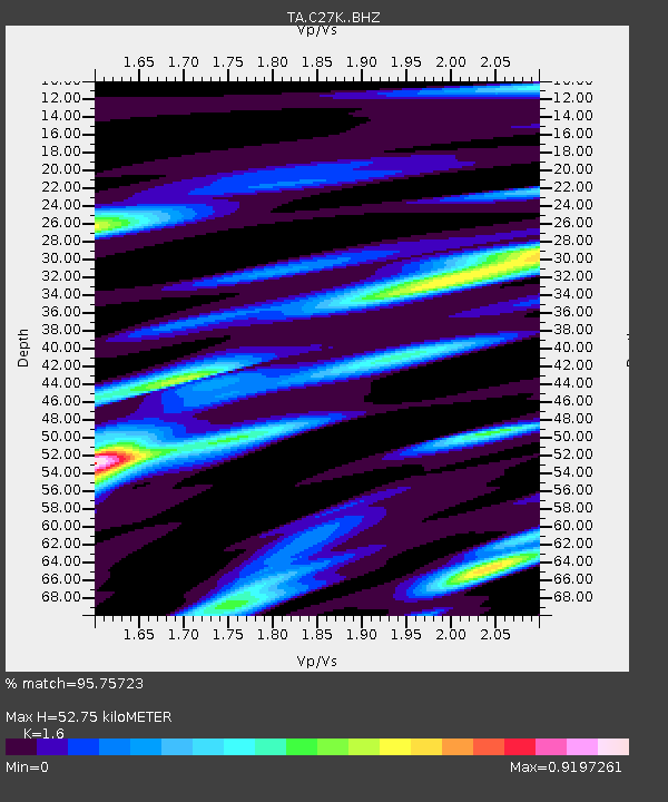
| Estimated Moho Depth: |
52.75 km |
| Estimated Crust Vp/Vs: |
1.60 |
| Assumed Crust Vp: |
6.522 km/s |
| Estimated Crust Vs: |
4.076 km/s |
| Estimated Crust Poisson's Ratio: |
0.18 |
|
| Radial Match: |
95.75723 % |
| Radial Bump: |
396 |
| Transverse Match: |
91.34944 % |
| Transverse Bump: |
400 |
| SOD ConfigId: |
11737051 |
| Insert Time: |
2019-04-26 16:14:28.087 +0000 |
| GWidth: |
2.5 |
| Max Bumps: |
400 |
| Tol: |
0.001 |
|

Signal To Noise
| Channel | StoN | STA | LTA |
| TA:C27K: :BHZ:20170119T23:16:37.425012Z | 10.901683 | 2.7294623E-6 | 2.5037073E-7 |
| TA:C27K: :BHN:20170119T23:16:37.425012Z | 2.4555416 | 7.6179725E-7 | 3.1023595E-7 |
| TA:C27K: :BHE:20170119T23:16:37.425012Z | 5.590316 | 6.357915E-7 | 1.1373087E-7 |
| Arrivals |
| Ps | 5.0 SECOND |
| PpPs | 21 SECOND |
| PsPs/PpSs | 25 SECOND |


