You are here: Home > Network List > TA - USArray Transportable Network (new EarthScope stations) Stations List
> Station D23K Nanushuk River, AK USA > Earthquake Result Viewer
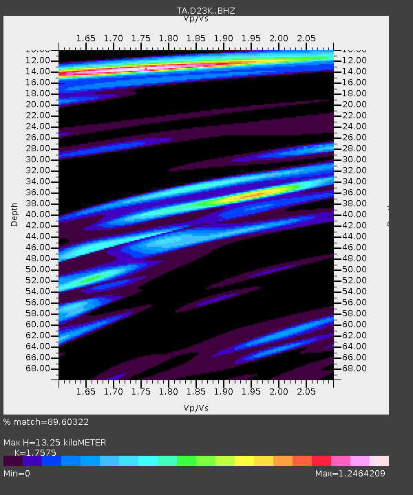
D23K Nanushuk River, AK USA - Earthquake Result Viewer
| Earthquake location: |
Solomon Islands |
| Earthquake latitude/longitude: |
-10.4/161.3 |
| Earthquake time(UTC): |
2017/01/19 (019) 23:04:20 GMT |
| Earthquake Depth: |
34 km |
| Earthquake Magnitude: |
6.8 mwp |
| Earthquake Catalog/Contributor: |
NEIC PDE/us |
|
| Network: |
TA USArray Transportable Network (new EarthScope stations) |
| Station: |
D23K Nanushuk River, AK USA |
| Lat/Lon: |
68.97 N/150.68 W |
| Elevation: |
406 m |
|
| Distance: |
85.9 deg |
| Az: |
15.614 deg |
| Baz: |
227.182 deg |
| Ray Param: |
0.044371895 |
| Estimated Moho Depth: |
13.25 km |
| Estimated Crust Vp/Vs: |
1.76 |
| Assumed Crust Vp: |
6.221 km/s |
| Estimated Crust Vs: |
3.54 km/s |
| Estimated Crust Poisson's Ratio: |
0.26 |
|
| Radial Match: |
89.60322 % |
| Radial Bump: |
400 |
| Transverse Match: |
85.48265 % |
| Transverse Bump: |
400 |
| SOD ConfigId: |
11737051 |
| Insert Time: |
2019-04-26 16:14:31.077 +0000 |
| GWidth: |
2.5 |
| Max Bumps: |
400 |
| Tol: |
0.001 |
|

Signal To Noise
| Channel | StoN | STA | LTA |
| TA:D23K: :BHZ:20170119T23:16:26.149988Z | 11.993559 | 3.02353E-6 | 2.5209616E-7 |
| TA:D23K: :BHN:20170119T23:16:26.149988Z | 3.2375624 | 6.3572287E-7 | 1.963585E-7 |
| TA:D23K: :BHE:20170119T23:16:26.149988Z | 1.9776787 | 6.0593607E-7 | 3.0638753E-7 |
| Arrivals |
| Ps | 1.6 SECOND |
| PpPs | 5.7 SECOND |
| PsPs/PpSs | 7.4 SECOND |


