You are here: Home > Network List > TA - USArray Transportable Network (new EarthScope stations) Stations List
> Station I29M Ogilvie Camp, Yukon, CA > Earthquake Result Viewer
I29M Ogilvie Camp, Yukon, CA - Earthquake Result Viewer
| Earthquake location: |
Solomon Islands |
| Earthquake latitude/longitude: |
-10.4/161.3 |
| Earthquake time(UTC): |
2017/01/19 (019) 23:04:20 GMT |
| Earthquake Depth: |
34 km |
| Earthquake Magnitude: |
6.8 mwp |
| Earthquake Catalog/Contributor: |
NEIC PDE/us |
|
| Network: |
TA USArray Transportable Network (new EarthScope stations) |
| Station: |
I29M Ogilvie Camp, Yukon, CA |
| Lat/Lon: |
65.36 N/138.31 W |
| Elevation: |
602 m |
|
| Distance: |
87.6 deg |
| Az: |
21.4 deg |
| Baz: |
238.914 deg |
| Ray Param: |
0.043153193 |
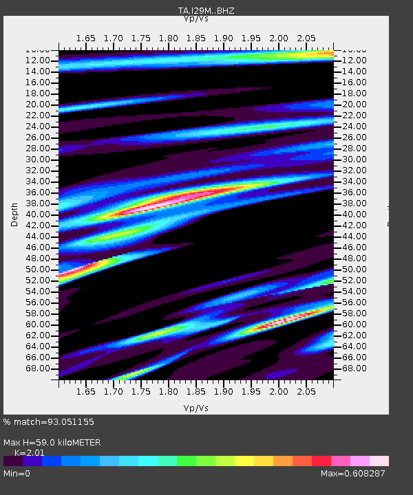
| Estimated Moho Depth: |
59.0 km |
| Estimated Crust Vp/Vs: |
2.01 |
| Assumed Crust Vp: |
6.566 km/s |
| Estimated Crust Vs: |
3.267 km/s |
| Estimated Crust Poisson's Ratio: |
0.34 |
|
| Radial Match: |
93.051155 % |
| Radial Bump: |
400 |
| Transverse Match: |
84.34453 % |
| Transverse Bump: |
400 |
| SOD ConfigId: |
11737051 |
| Insert Time: |
2019-04-26 16:14:50.466 +0000 |
| GWidth: |
2.5 |
| Max Bumps: |
400 |
| Tol: |
0.001 |
|

Signal To Noise
| Channel | StoN | STA | LTA |
| TA:I29M: :BHZ:20170119T23:16:34.350Z | 18.053135 | 2.9029516E-6 | 1.6080041E-7 |
| TA:I29M: :BHN:20170119T23:16:34.350Z | 3.883063 | 5.602846E-7 | 1.4428933E-7 |
| TA:I29M: :BHE:20170119T23:16:34.350Z | 7.249697 | 8.1316807E-7 | 1.1216579E-7 |
| Arrivals |
| Ps | 9.3 SECOND |
| PpPs | 26 SECOND |
| PsPs/PpSs | 36 SECOND |


