You are here: Home > Network List > TA - USArray Transportable Network (new EarthScope stations) Stations List
> Station L19K White Mountain, AK, USA > Earthquake Result Viewer
L19K White Mountain, AK, USA - Earthquake Result Viewer
| Earthquake location: |
Solomon Islands |
| Earthquake latitude/longitude: |
-10.4/161.3 |
| Earthquake time(UTC): |
2017/01/19 (019) 23:04:20 GMT |
| Earthquake Depth: |
34 km |
| Earthquake Magnitude: |
6.8 mwp |
| Earthquake Catalog/Contributor: |
NEIC PDE/us |
|
| Network: |
TA USArray Transportable Network (new EarthScope stations) |
| Station: |
L19K White Mountain, AK, USA |
| Lat/Lon: |
62.18 N/154.85 W |
| Elevation: |
650 m |
|
| Distance: |
79.9 deg |
| Az: |
19.281 deg |
| Baz: |
223.832 deg |
| Ray Param: |
0.048589133 |
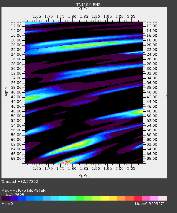
| Estimated Moho Depth: |
69.75 km |
| Estimated Crust Vp/Vs: |
1.76 |
| Assumed Crust Vp: |
6.438 km/s |
| Estimated Crust Vs: |
3.653 km/s |
| Estimated Crust Poisson's Ratio: |
0.26 |
|
| Radial Match: |
82.27352 % |
| Radial Bump: |
400 |
| Transverse Match: |
67.14923 % |
| Transverse Bump: |
400 |
| SOD ConfigId: |
11737051 |
| Insert Time: |
2019-04-26 16:14:55.184 +0000 |
| GWidth: |
2.5 |
| Max Bumps: |
400 |
| Tol: |
0.001 |
|
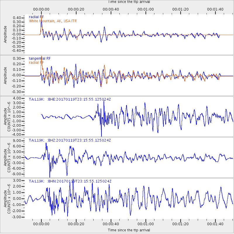
Signal To Noise
| Channel | StoN | STA | LTA |
| TA:L19K: :BHZ:20170119T23:15:55.125024Z | 8.182436 | 3.4840953E-6 | 4.2580172E-7 |
| TA:L19K: :BHN:20170119T23:15:55.125024Z | 2.0294344 | 8.1861646E-7 | 4.0337173E-7 |
| TA:L19K: :BHE:20170119T23:15:55.125024Z | 5.354973 | 1.3025804E-6 | 2.4324686E-7 |
| Arrivals |
| Ps | 8.5 SECOND |
| PpPs | 29 SECOND |
| PsPs/PpSs | 38 SECOND |


