You are here: Home > Network List > TA - USArray Transportable Network (new EarthScope stations) Stations List
> Station L29M Grand Valley Creek, YT, CAN > Earthquake Result Viewer
L29M Grand Valley Creek, YT, CAN - Earthquake Result Viewer
| Earthquake location: |
Solomon Islands |
| Earthquake latitude/longitude: |
-10.4/161.3 |
| Earthquake time(UTC): |
2017/01/19 (019) 23:04:20 GMT |
| Earthquake Depth: |
34 km |
| Earthquake Magnitude: |
6.8 mwp |
| Earthquake Catalog/Contributor: |
NEIC PDE/us |
|
| Network: |
TA USArray Transportable Network (new EarthScope stations) |
| Station: |
L29M Grand Valley Creek, YT, CAN |
| Lat/Lon: |
63.11 N/138.13 W |
| Elevation: |
918 m |
|
| Distance: |
86.5 deg |
| Az: |
23.382 deg |
| Baz: |
239.175 deg |
| Ray Param: |
0.043948993 |
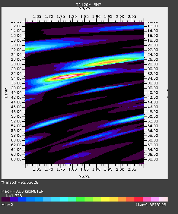
| Estimated Moho Depth: |
33.0 km |
| Estimated Crust Vp/Vs: |
1.77 |
| Assumed Crust Vp: |
6.566 km/s |
| Estimated Crust Vs: |
3.699 km/s |
| Estimated Crust Poisson's Ratio: |
0.27 |
|
| Radial Match: |
93.05026 % |
| Radial Bump: |
332 |
| Transverse Match: |
86.863045 % |
| Transverse Bump: |
379 |
| SOD ConfigId: |
11737051 |
| Insert Time: |
2019-04-26 16:14:57.742 +0000 |
| GWidth: |
2.5 |
| Max Bumps: |
400 |
| Tol: |
0.001 |
|
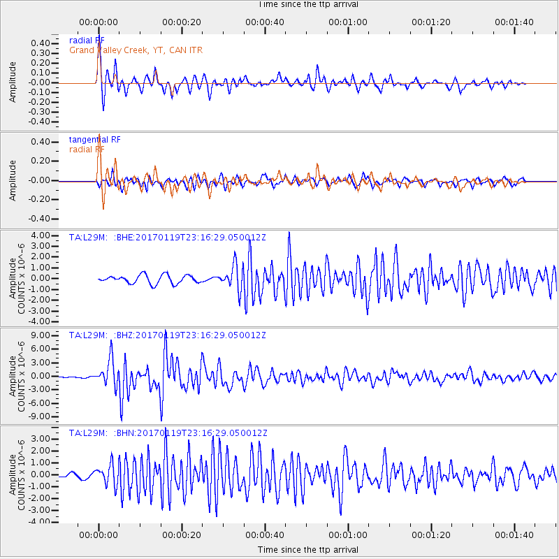
Signal To Noise
| Channel | StoN | STA | LTA |
| TA:L29M: :BHZ:20170119T23:16:29.050012Z | 24.47035 | 2.9878577E-6 | 1.2210114E-7 |
| TA:L29M: :BHN:20170119T23:16:29.050012Z | 5.507795 | 8.6676494E-7 | 1.573706E-7 |
| TA:L29M: :BHE:20170119T23:16:29.050012Z | 2.903433 | 1.135797E-6 | 3.9119104E-7 |
| Arrivals |
| Ps | 4.0 SECOND |
| PpPs | 14 SECOND |
| PsPs/PpSs | 18 SECOND |


