You are here: Home > Network List > TA - USArray Transportable Network (new EarthScope stations) Stations List
> Station R17K Ugashik Creek, AK, USA > Earthquake Result Viewer
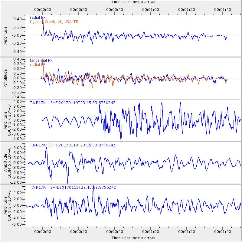
R17K Ugashik Creek, AK, USA - Earthquake Result Viewer
*The percent match for this event was below the threshold and hence no stack was calculated.
| Earthquake location: |
Solomon Islands |
| Earthquake latitude/longitude: |
-10.4/161.3 |
| Earthquake time(UTC): |
2017/01/19 (019) 23:04:20 GMT |
| Earthquake Depth: |
34 km |
| Earthquake Magnitude: |
6.8 mwp |
| Earthquake Catalog/Contributor: |
NEIC PDE/us |
|
| Network: |
TA USArray Transportable Network (new EarthScope stations) |
| Station: |
R17K Ugashik Creek, AK, USA |
| Lat/Lon: |
57.64 N/156.39 W |
| Elevation: |
273 m |
|
| Distance: |
76.1 deg |
| Az: |
21.91 deg |
| Baz: |
223.055 deg |
| Ray Param: |
$rayparam |
*The percent match for this event was below the threshold and hence was not used in the summary stack. |
|
| Radial Match: |
79.29294 % |
| Radial Bump: |
400 |
| Transverse Match: |
70.57087 % |
| Transverse Bump: |
400 |
| SOD ConfigId: |
11737051 |
| Insert Time: |
2019-04-26 16:15:36.204 +0000 |
| GWidth: |
2.5 |
| Max Bumps: |
400 |
| Tol: |
0.001 |
|
Signal To Noise
| Channel | StoN | STA | LTA |
| TA:R17K: :BHZ:20170119T23:15:33.875024Z | 8.118598 | 5.1105667E-6 | 6.2948885E-7 |
| TA:R17K: :BHN:20170119T23:15:33.875024Z | 2.005953 | 1.2818492E-6 | 6.390225E-7 |
| TA:R17K: :BHE:20170119T23:15:33.875024Z | 1.9200044 | 1.3684928E-6 | 7.12755E-7 |
| Arrivals |
| Ps | |
| PpPs | |
| PsPs/PpSs | |


