You are here: Home > Network List > TA - USArray Transportable Network (new EarthScope stations) Stations List
> Station R33M Jennings River, BC, CAN > Earthquake Result Viewer
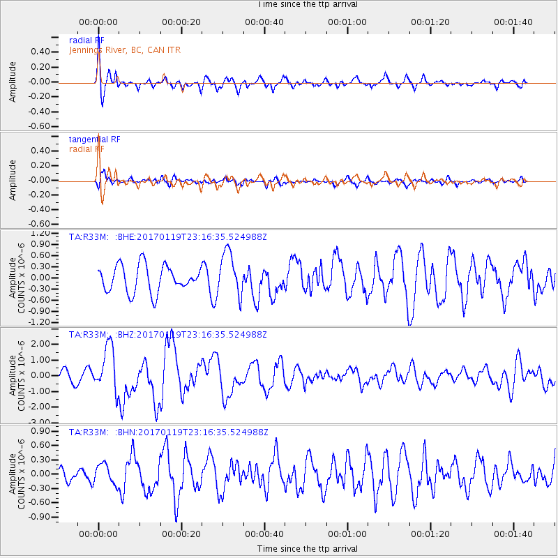
R33M Jennings River, BC, CAN - Earthquake Result Viewer
*The percent match for this event was below the threshold and hence no stack was calculated.
| Earthquake location: |
Solomon Islands |
| Earthquake latitude/longitude: |
-10.4/161.3 |
| Earthquake time(UTC): |
2017/01/19 (019) 23:04:20 GMT |
| Earthquake Depth: |
34 km |
| Earthquake Magnitude: |
6.8 mwp |
| Earthquake Catalog/Contributor: |
NEIC PDE/us |
|
| Network: |
TA USArray Transportable Network (new EarthScope stations) |
| Station: |
R33M Jennings River, BC, CAN |
| Lat/Lon: |
59.39 N/130.97 W |
| Elevation: |
1437 m |
|
| Distance: |
87.9 deg |
| Az: |
28.288 deg |
| Baz: |
245.689 deg |
| Ray Param: |
$rayparam |
*The percent match for this event was below the threshold and hence was not used in the summary stack. |
|
| Radial Match: |
69.943375 % |
| Radial Bump: |
400 |
| Transverse Match: |
60.534943 % |
| Transverse Bump: |
400 |
| SOD ConfigId: |
11737051 |
| Insert Time: |
2019-04-26 16:15:37.520 +0000 |
| GWidth: |
2.5 |
| Max Bumps: |
400 |
| Tol: |
0.001 |
|
Signal To Noise
| Channel | StoN | STA | LTA |
| TA:R33M: :BHZ:20170119T23:16:35.524988Z | 3.8381345 | 1.5112416E-6 | 3.937438E-7 |
| TA:R33M: :BHN:20170119T23:16:35.524988Z | 0.8496415 | 2.1241905E-7 | 2.500102E-7 |
| TA:R33M: :BHE:20170119T23:16:35.524988Z | 1.6793737 | 5.9480186E-7 | 3.5418074E-7 |
| Arrivals |
| Ps | |
| PpPs | |
| PsPs/PpSs | |


