You are here: Home > Network List > YT07 - POLENET Stations List
> Station SILY SILY > Earthquake Result Viewer
SILY SILY - Earthquake Result Viewer
| Earthquake location: |
Solomon Islands |
| Earthquake latitude/longitude: |
-10.4/161.3 |
| Earthquake time(UTC): |
2017/01/19 (019) 23:04:20 GMT |
| Earthquake Depth: |
34 km |
| Earthquake Magnitude: |
6.8 mwp |
| Earthquake Catalog/Contributor: |
NEIC PDE/us |
|
| Network: |
YT POLENET |
| Station: |
SILY SILY |
| Lat/Lon: |
77.13 S/125.97 W |
| Elevation: |
2093 m |
|
| Distance: |
76.2 deg |
| Az: |
167.265 deg |
| Baz: |
284.572 deg |
| Ray Param: |
0.05113813 |
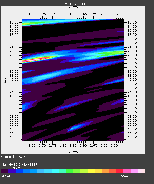
| Estimated Moho Depth: |
30.0 km |
| Estimated Crust Vp/Vs: |
1.66 |
| Assumed Crust Vp: |
6.138 km/s |
| Estimated Crust Vs: |
3.703 km/s |
| Estimated Crust Poisson's Ratio: |
0.21 |
|
| Radial Match: |
96.977 % |
| Radial Bump: |
240 |
| Transverse Match: |
89.82713 % |
| Transverse Bump: |
341 |
| SOD ConfigId: |
11737051 |
| Insert Time: |
2019-04-26 16:18:06.921 +0000 |
| GWidth: |
2.5 |
| Max Bumps: |
400 |
| Tol: |
0.001 |
|

Signal To Noise
| Channel | StoN | STA | LTA |
| YT:SILY: :BHZ:20170119T23:15:34.448999Z | 35.818726 | 4.3437544E-6 | 1.212705E-7 |
| YT:SILY: :BHN:20170119T23:15:34.448999Z | 4.095607 | 7.5941847E-7 | 1.8542269E-7 |
| YT:SILY: :BHE:20170119T23:15:34.448999Z | 14.489548 | 1.6815721E-6 | 1.16054146E-7 |
| Arrivals |
| Ps | 3.3 SECOND |
| PpPs | 13 SECOND |
| PsPs/PpSs | 16 SECOND |


