You are here: Home > Network List > YT07 - POLENET Stations List
> Station PECA PECA > Earthquake Result Viewer
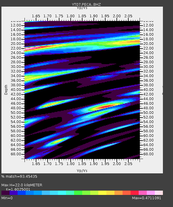
PECA PECA - Earthquake Result Viewer
| Earthquake location: |
Solomon Islands |
| Earthquake latitude/longitude: |
-10.4/161.3 |
| Earthquake time(UTC): |
2017/01/19 (019) 23:04:20 GMT |
| Earthquake Depth: |
34 km |
| Earthquake Magnitude: |
6.8 mwp |
| Earthquake Catalog/Contributor: |
NEIC PDE/us |
|
| Network: |
YT POLENET |
| Station: |
PECA PECA |
| Lat/Lon: |
85.61 S/68.55 W |
| Elevation: |
1514 m |
|
| Distance: |
82.6 deg |
| Az: |
176.598 deg |
| Baz: |
229.308 deg |
| Ray Param: |
0.046741985 |
| Estimated Moho Depth: |
22.0 km |
| Estimated Crust Vp/Vs: |
1.60 |
| Assumed Crust Vp: |
6.39 km/s |
| Estimated Crust Vs: |
3.987 km/s |
| Estimated Crust Poisson's Ratio: |
0.18 |
|
| Radial Match: |
93.45435 % |
| Radial Bump: |
400 |
| Transverse Match: |
70.04407 % |
| Transverse Bump: |
400 |
| SOD ConfigId: |
11737051 |
| Insert Time: |
2019-04-26 16:18:07.031 +0000 |
| GWidth: |
2.5 |
| Max Bumps: |
400 |
| Tol: |
0.001 |
|

Signal To Noise
| Channel | StoN | STA | LTA |
| YT:PECA: :BHZ:20170119T23:16:09.375024Z | 41.46857 | 3.5007138E-6 | 8.441848E-8 |
| YT:PECA: :BHN:20170119T23:16:09.375024Z | 6.8150907 | 6.2759045E-7 | 9.208835E-8 |
| YT:PECA: :BHE:20170119T23:16:09.375024Z | 5.785135 | 8.5916867E-7 | 1.4851317E-7 |
| Arrivals |
| Ps | 2.1 SECOND |
| PpPs | 8.7 SECOND |
| PsPs/PpSs | 11 SECOND |


