You are here: Home > Network List > CI - Caltech Regional Seismic Network Stations List
> Station SWS Sam W. Stewart, Westmorland, CA, USA > Earthquake Result Viewer
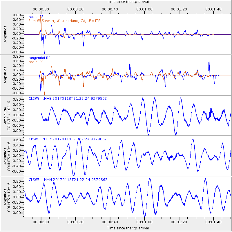
SWS Sam W. Stewart, Westmorland, CA, USA - Earthquake Result Viewer
*The percent match for this event was below the threshold and hence no stack was calculated.
| Earthquake location: |
Hawaii |
| Earthquake latitude/longitude: |
21.6/-157.5 |
| Earthquake time(UTC): |
2017/01/18 (018) 21:15:34 GMT |
| Earthquake Depth: |
15 km |
| Earthquake Magnitude: |
2.7 Ml |
| Earthquake Catalog/Contributor: |
NEIC PDE/hv |
|
| Network: |
CI Caltech Regional Seismic Network |
| Station: |
SWS Sam W. Stewart, Westmorland, CA, USA |
| Lat/Lon: |
32.94 N/115.80 W |
| Elevation: |
140 m |
|
| Distance: |
38.5 deg |
| Az: |
63.901 deg |
| Baz: |
263.68 deg |
| Ray Param: |
$rayparam |
*The percent match for this event was below the threshold and hence was not used in the summary stack. |
|
| Radial Match: |
74.46856 % |
| Radial Bump: |
357 |
| Transverse Match: |
53.730545 % |
| Transverse Bump: |
289 |
| SOD ConfigId: |
11737051 |
| Insert Time: |
2019-04-26 16:20:19.522 +0000 |
| GWidth: |
2.5 |
| Max Bumps: |
400 |
| Tol: |
0.001 |
|
Signal To Noise
| Channel | StoN | STA | LTA |
| CI:SWS: :HHZ:20170118T21:22:24.937986Z | 1.3732629 | 3.3637667E-7 | 2.4494705E-7 |
| CI:SWS: :HHN:20170118T21:22:24.937986Z | 0.6890568 | 5.359456E-7 | 7.777959E-7 |
| CI:SWS: :HHE:20170118T21:22:24.937986Z | 1.1783507 | 2.8155634E-7 | 2.3894106E-7 |
| Arrivals |
| Ps | |
| PpPs | |
| PsPs/PpSs | |


