You are here: Home > Network List > UW - Pacific Northwest Regional Seismic Network Stations List
> Station LTY Liberty (broad-band) > Earthquake Result Viewer
LTY Liberty (broad-band) - Earthquake Result Viewer
*The percent match for this event was below the threshold and hence no stack was calculated.
| Earthquake location: |
Hawaii |
| Earthquake latitude/longitude: |
21.6/-157.5 |
| Earthquake time(UTC): |
2017/01/18 (018) 21:15:34 GMT |
| Earthquake Depth: |
15 km |
| Earthquake Magnitude: |
2.7 Ml |
| Earthquake Catalog/Contributor: |
NEIC PDE/hv |
|
| Network: |
UW Pacific Northwest Regional Seismic Network |
| Station: |
LTY Liberty (broad-band) |
| Lat/Lon: |
47.26 N/120.66 W |
| Elevation: |
970 m |
|
| Distance: |
39.2 deg |
| Az: |
40.267 deg |
| Baz: |
242.017 deg |
| Ray Param: |
$rayparam |
*The percent match for this event was below the threshold and hence was not used in the summary stack. |
|
| Radial Match: |
48.906277 % |
| Radial Bump: |
400 |
| Transverse Match: |
68.43401 % |
| Transverse Bump: |
400 |
| SOD ConfigId: |
11737051 |
| Insert Time: |
2019-04-26 16:26:04.172 +0000 |
| GWidth: |
2.5 |
| Max Bumps: |
400 |
| Tol: |
0.001 |
|
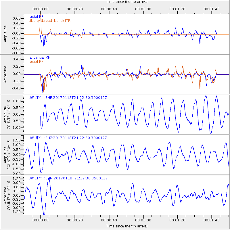
Signal To Noise
| Channel | StoN | STA | LTA |
| UW:LTY: :BHZ:20170118T21:22:30.390012Z | 3.3861377 | 1.1327302E-6 | 3.345198E-7 |
| UW:LTY: :BHN:20170118T21:22:30.390012Z | 2.976928 | 9.1174655E-7 | 3.0627095E-7 |
| UW:LTY: :BHE:20170118T21:22:30.390012Z | 0.6843468 | 3.716707E-7 | 5.4310283E-7 |
| Arrivals |
| Ps | |
| PpPs | |
| PsPs/PpSs | |


