You are here: Home > Network List > 2H - Interim Broadband Monitoring of the Mount Erebus Volcano Stations List
> Station ICEZ Mt Erebus site ICE > Earthquake Result Viewer
ICEZ Mt Erebus site ICE - Earthquake Result Viewer
| Earthquake location: |
Solomon Islands |
| Earthquake latitude/longitude: |
-6.2/155.1 |
| Earthquake time(UTC): |
2017/01/22 (022) 04:30:23 GMT |
| Earthquake Depth: |
136 km |
| Earthquake Magnitude: |
7.9 mww |
| Earthquake Catalog/Contributor: |
NEIC PDE/us |
|
| Network: |
2H Interim Broadband Monitoring of the Mount Erebus Volcano |
| Station: |
ICEZ Mt Erebus site ICE |
| Lat/Lon: |
77.55 S/167.28 E |
| Elevation: |
2370 m |
|
| Distance: |
71.6 deg |
| Az: |
177.24 deg |
| Baz: |
347.249 deg |
| Ray Param: |
0.053871315 |
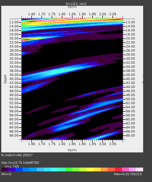
| Estimated Moho Depth: |
10.75 km |
| Estimated Crust Vp/Vs: |
1.75 |
| Assumed Crust Vp: |
6.183 km/s |
| Estimated Crust Vs: |
3.543 km/s |
| Estimated Crust Poisson's Ratio: |
0.26 |
|
| Radial Match: |
98.29007 % |
| Radial Bump: |
289 |
| Transverse Match: |
90.63981 % |
| Transverse Bump: |
400 |
| SOD ConfigId: |
11737051 |
| Insert Time: |
2019-04-26 16:36:50.159 +0000 |
| GWidth: |
2.5 |
| Max Bumps: |
400 |
| Tol: |
0.001 |
|

Signal To Noise
| Channel | StoN | STA | LTA |
| 2H:ICEZ: :HHZ:20170122T04:40:58.663987Z | 14.680156 | 1.8239632E-5 | 1.2424687E-6 |
| 2H:ICEZ: :HH1:20170122T04:40:58.663987Z | 10.559601 | 8.142733E-6 | 7.711213E-7 |
| 2H:ICEZ: :HH2:20170122T04:40:58.663987Z | 6.733264 | 3.4490008E-6 | 5.1223316E-7 |
| Arrivals |
| Ps | 1.3 SECOND |
| PpPs | 4.6 SECOND |
| PsPs/PpSs | 6.0 SECOND |


