You are here: Home > Network List > AK - Alaska Regional Network Stations List
> Station CYK Cape Yakataga, AK, USA > Earthquake Result Viewer
CYK Cape Yakataga, AK, USA - Earthquake Result Viewer
| Earthquake location: |
Solomon Islands |
| Earthquake latitude/longitude: |
-6.2/155.1 |
| Earthquake time(UTC): |
2017/01/22 (022) 04:30:23 GMT |
| Earthquake Depth: |
136 km |
| Earthquake Magnitude: |
7.9 mww |
| Earthquake Catalog/Contributor: |
NEIC PDE/us |
|
| Network: |
AK Alaska Regional Network |
| Station: |
CYK Cape Yakataga, AK, USA |
| Lat/Lon: |
60.08 N/142.49 W |
| Elevation: |
23 m |
|
| Distance: |
82.1 deg |
| Az: |
26.646 deg |
| Baz: |
242.809 deg |
| Ray Param: |
0.046829306 |
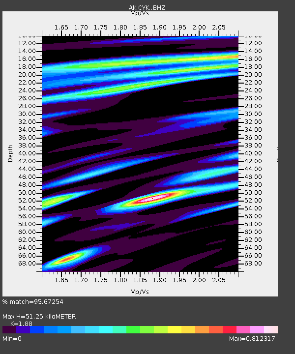
| Estimated Moho Depth: |
51.25 km |
| Estimated Crust Vp/Vs: |
1.88 |
| Assumed Crust Vp: |
6.566 km/s |
| Estimated Crust Vs: |
3.493 km/s |
| Estimated Crust Poisson's Ratio: |
0.30 |
|
| Radial Match: |
95.67254 % |
| Radial Bump: |
400 |
| Transverse Match: |
91.74564 % |
| Transverse Bump: |
400 |
| SOD ConfigId: |
11737051 |
| Insert Time: |
2019-04-26 16:37:13.556 +0000 |
| GWidth: |
2.5 |
| Max Bumps: |
400 |
| Tol: |
0.001 |
|

Signal To Noise
| Channel | StoN | STA | LTA |
| AK:CYK: :BHZ:20170122T04:41:57.168015Z | 13.411591 | 2.1574551E-5 | 1.6086497E-6 |
| AK:CYK: :BHN:20170122T04:41:57.168015Z | 4.416762 | 3.0999688E-6 | 7.018646E-7 |
| AK:CYK: :BHE:20170122T04:41:57.168015Z | 6.774109 | 6.2474246E-6 | 9.2225036E-7 |
| Arrivals |
| Ps | 7.0 SECOND |
| PpPs | 22 SECOND |
| PsPs/PpSs | 29 SECOND |


