You are here: Home > Network List > CI - Caltech Regional Seismic Network Stations List
> Station DJJ Donna Jones Jenkins, California, USA > Earthquake Result Viewer
DJJ Donna Jones Jenkins, California, USA - Earthquake Result Viewer
| Earthquake location: |
Samoa Islands Region |
| Earthquake latitude/longitude: |
-15.5/-172.1 |
| Earthquake time(UTC): |
2009/09/29 (272) 17:48:10 GMT |
| Earthquake Depth: |
18 km |
| Earthquake Magnitude: |
7.1 MB, 8.1 MS, 8.1 MW, 8.0 MW |
| Earthquake Catalog/Contributor: |
WHDF/NEIC |
|
| Network: |
CI Caltech Regional Seismic Network |
| Station: |
DJJ Donna Jones Jenkins, California, USA |
| Lat/Lon: |
34.11 N/118.45 W |
| Elevation: |
245 m |
|
| Distance: |
71.0 deg |
| Az: |
44.98 deg |
| Baz: |
235.22 deg |
| Ray Param: |
0.054617345 |
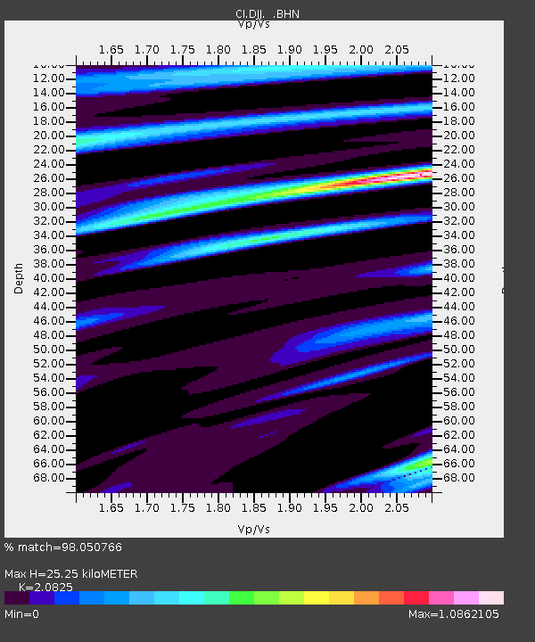
| Estimated Moho Depth: |
25.25 km |
| Estimated Crust Vp/Vs: |
2.08 |
| Assumed Crust Vp: |
6.1 km/s |
| Estimated Crust Vs: |
2.929 km/s |
| Estimated Crust Poisson's Ratio: |
0.35 |
|
| Radial Match: |
98.050766 % |
| Radial Bump: |
400 |
| Transverse Match: |
90.79046 % |
| Transverse Bump: |
400 |
| SOD ConfigId: |
2622 |
| Insert Time: |
2010-03-05 21:45:33.973 +0000 |
| GWidth: |
2.5 |
| Max Bumps: |
400 |
| Tol: |
0.001 |
|

Signal To Noise
| Channel | StoN | STA | LTA |
| CI:DJJ: :BHN:20090929T17:58:56.068003Z | 6.8847084 | 2.9273751E-6 | 4.2519957E-7 |
| CI:DJJ: :BHE:20090929T17:58:56.068003Z | 2.35188 | 9.080292E-7 | 3.8608653E-7 |
| CI:DJJ: :BHZ:20090929T17:58:56.068003Z | 6.626724 | 1.2596327E-6 | 1.9008378E-7 |
| Arrivals |
| Ps | 4.6 SECOND |
| PpPs | 12 SECOND |
| PsPs/PpSs | 17 SECOND |


