You are here: Home > Network List > AK - Alaska Regional Network Stations List
> Station RIDG Independent Ridge > Earthquake Result Viewer
RIDG Independent Ridge - Earthquake Result Viewer
| Earthquake location: |
Solomon Islands |
| Earthquake latitude/longitude: |
-6.2/155.1 |
| Earthquake time(UTC): |
2017/01/22 (022) 04:30:23 GMT |
| Earthquake Depth: |
136 km |
| Earthquake Magnitude: |
7.9 mww |
| Earthquake Catalog/Contributor: |
NEIC PDE/us |
|
| Network: |
AK Alaska Regional Network |
| Station: |
RIDG Independent Ridge |
| Lat/Lon: |
63.74 N/144.84 W |
| Elevation: |
888 m |
|
| Distance: |
82.8 deg |
| Az: |
22.855 deg |
| Baz: |
240.236 deg |
| Ray Param: |
0.046296146 |
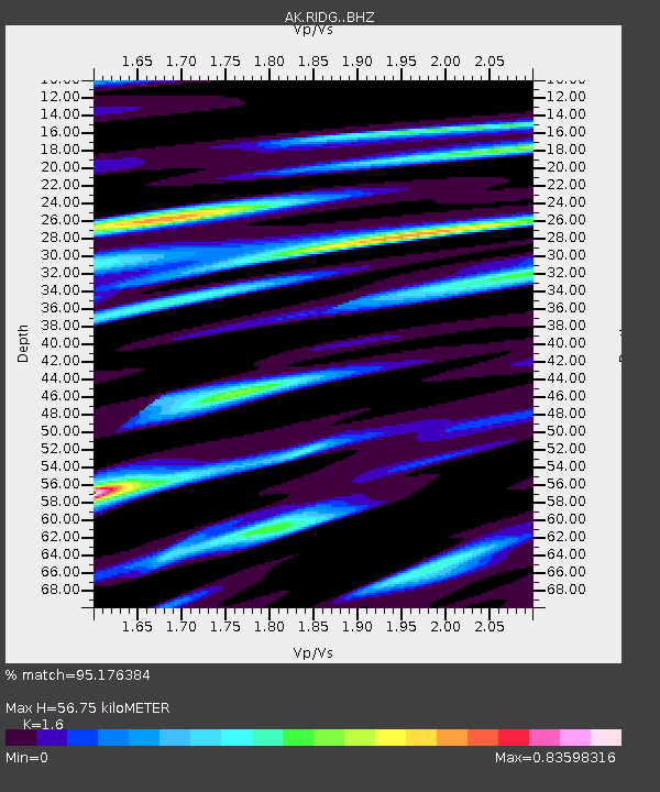
| Estimated Moho Depth: |
56.75 km |
| Estimated Crust Vp/Vs: |
1.60 |
| Assumed Crust Vp: |
6.566 km/s |
| Estimated Crust Vs: |
4.104 km/s |
| Estimated Crust Poisson's Ratio: |
0.18 |
|
| Radial Match: |
95.176384 % |
| Radial Bump: |
400 |
| Transverse Match: |
88.70817 % |
| Transverse Bump: |
400 |
| SOD ConfigId: |
11737051 |
| Insert Time: |
2019-04-26 16:37:40.181 +0000 |
| GWidth: |
2.5 |
| Max Bumps: |
400 |
| Tol: |
0.001 |
|

Signal To Noise
| Channel | StoN | STA | LTA |
| AK:RIDG: :BHZ:20170122T04:42:01.147996Z | 17.501766 | 2.03184E-5 | 1.1609343E-6 |
| AK:RIDG: :BHN:20170122T04:42:01.147996Z | 7.393432 | 2.3006144E-6 | 3.1117E-7 |
| AK:RIDG: :BHE:20170122T04:42:01.147996Z | 14.902323 | 7.02094E-6 | 4.711306E-7 |
| Arrivals |
| Ps | 5.3 SECOND |
| PpPs | 22 SECOND |
| PsPs/PpSs | 27 SECOND |


