You are here: Home > Network List > AK - Alaska Regional Network Stations List
> Station SGA Sherman Glacier, AK, USA > Earthquake Result Viewer
SGA Sherman Glacier, AK, USA - Earthquake Result Viewer
| Earthquake location: |
Solomon Islands |
| Earthquake latitude/longitude: |
-6.2/155.1 |
| Earthquake time(UTC): |
2017/01/22 (022) 04:30:23 GMT |
| Earthquake Depth: |
136 km |
| Earthquake Magnitude: |
7.9 mww |
| Earthquake Catalog/Contributor: |
NEIC PDE/us |
|
| Network: |
AK Alaska Regional Network |
| Station: |
SGA Sherman Glacier, AK, USA |
| Lat/Lon: |
60.53 N/145.21 W |
| Elevation: |
450 m |
|
| Distance: |
81.1 deg |
| Az: |
25.591 deg |
| Baz: |
240.295 deg |
| Ray Param: |
0.047505066 |
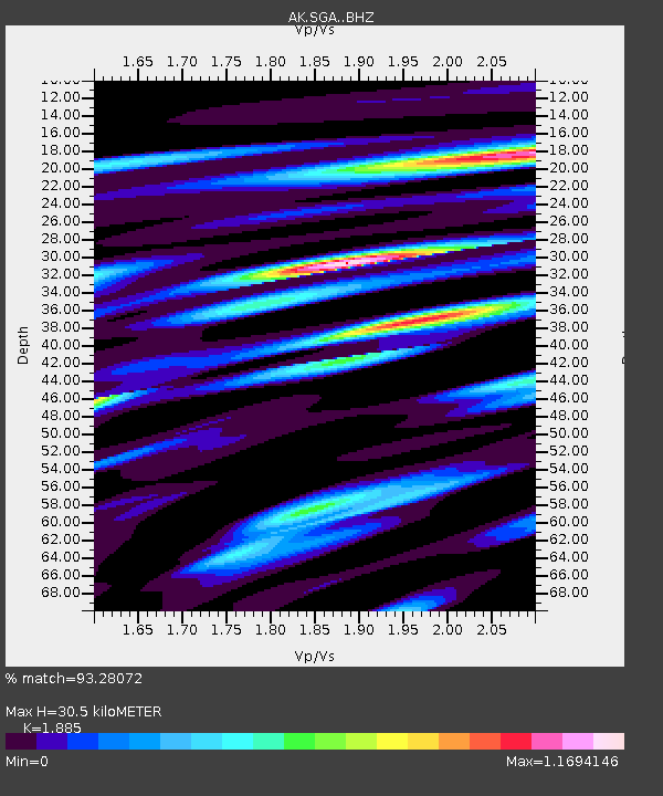
| Estimated Moho Depth: |
30.5 km |
| Estimated Crust Vp/Vs: |
1.88 |
| Assumed Crust Vp: |
6.566 km/s |
| Estimated Crust Vs: |
3.483 km/s |
| Estimated Crust Poisson's Ratio: |
0.30 |
|
| Radial Match: |
93.28072 % |
| Radial Bump: |
400 |
| Transverse Match: |
88.90875 % |
| Transverse Bump: |
400 |
| SOD ConfigId: |
11737051 |
| Insert Time: |
2019-04-26 16:37:45.049 +0000 |
| GWidth: |
2.5 |
| Max Bumps: |
400 |
| Tol: |
0.001 |
|

Signal To Noise
| Channel | StoN | STA | LTA |
| AK:SGA: :BHZ:20170122T04:41:52.067979Z | 12.048791 | 2.054413E-5 | 1.7050781E-6 |
| AK:SGA: :BHN:20170122T04:41:52.067979Z | 7.2402706 | 4.6617097E-6 | 6.4385847E-7 |
| AK:SGA: :BHE:20170122T04:41:52.067979Z | 9.725076 | 8.527437E-6 | 8.7685044E-7 |
| Arrivals |
| Ps | 4.2 SECOND |
| PpPs | 13 SECOND |
| PsPs/PpSs | 17 SECOND |


