You are here: Home > Network List > AV - Alaska Volcano Observatory Stations List
> Station AKSA Akutan Strait, Akutan Volcano, Alaska > Earthquake Result Viewer
AKSA Akutan Strait, Akutan Volcano, Alaska - Earthquake Result Viewer
| Earthquake location: |
Solomon Islands |
| Earthquake latitude/longitude: |
-6.2/155.1 |
| Earthquake time(UTC): |
2017/01/22 (022) 04:30:23 GMT |
| Earthquake Depth: |
136 km |
| Earthquake Magnitude: |
7.9 mww |
| Earthquake Catalog/Contributor: |
NEIC PDE/us |
|
| Network: |
AV Alaska Volcano Observatory |
| Station: |
AKSA Akutan Strait, Akutan Volcano, Alaska |
| Lat/Lon: |
54.11 N/165.70 W |
| Elevation: |
213 m |
|
| Distance: |
68.5 deg |
| Az: |
23.57 deg |
| Baz: |
222.467 deg |
| Ray Param: |
0.05591509 |
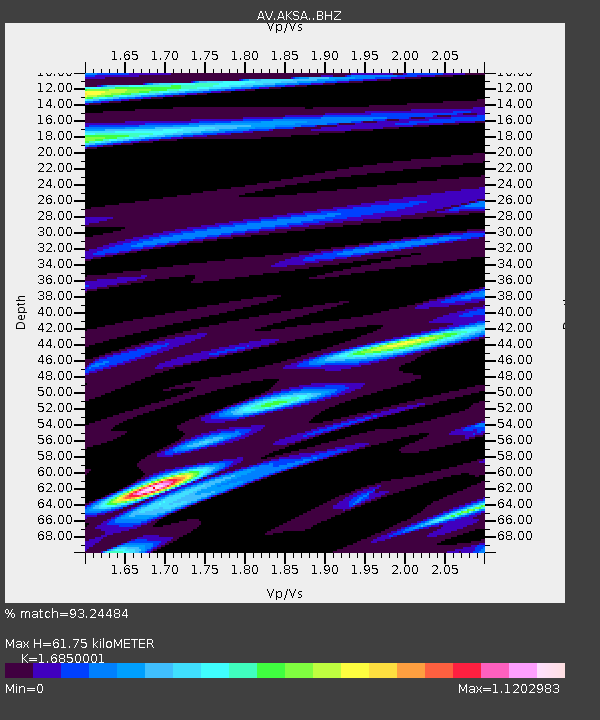
| Estimated Moho Depth: |
61.75 km |
| Estimated Crust Vp/Vs: |
1.69 |
| Assumed Crust Vp: |
5.989 km/s |
| Estimated Crust Vs: |
3.554 km/s |
| Estimated Crust Poisson's Ratio: |
0.23 |
|
| Radial Match: |
93.24484 % |
| Radial Bump: |
400 |
| Transverse Match: |
89.4057 % |
| Transverse Bump: |
400 |
| SOD ConfigId: |
11737051 |
| Insert Time: |
2019-04-26 16:38:22.708 +0000 |
| GWidth: |
2.5 |
| Max Bumps: |
400 |
| Tol: |
0.001 |
|
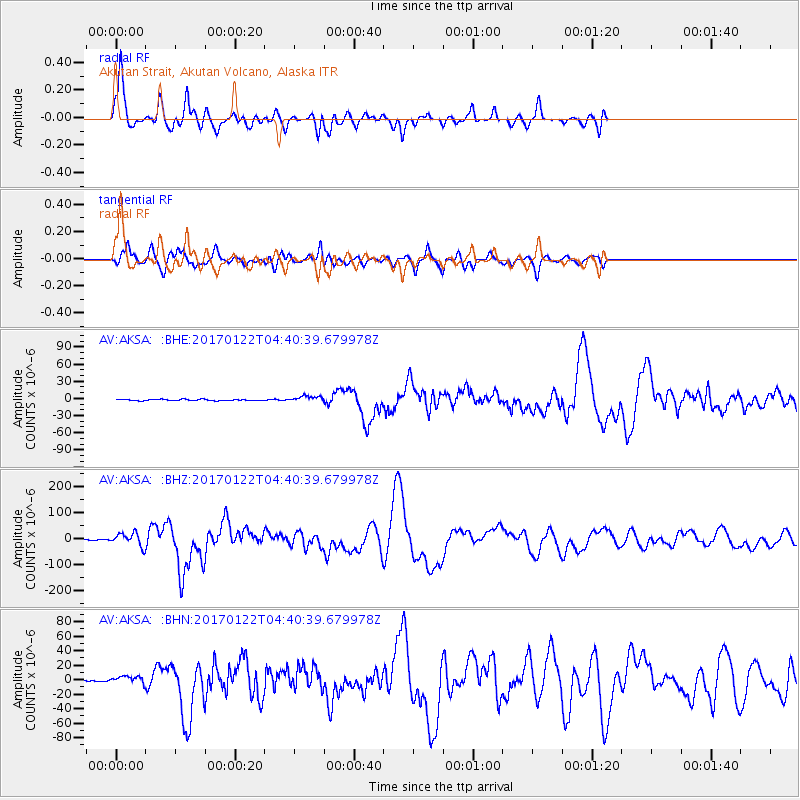
Signal To Noise
| Channel | StoN | STA | LTA |
| AV:AKSA: :BHZ:20170122T04:40:39.679978Z | 15.419423 | 2.55552E-5 | 1.6573383E-6 |
| AV:AKSA: :BHN:20170122T04:40:39.679978Z | 4.410519 | 5.6538875E-6 | 1.2819098E-6 |
| AV:AKSA: :BHE:20170122T04:40:39.679978Z | 4.6623583 | 5.2742575E-6 | 1.1312425E-6 |
| Arrivals |
| Ps | 7.3 SECOND |
| PpPs | 27 SECOND |
| PsPs/PpSs | 34 SECOND |


