You are here: Home > Network List > AV - Alaska Volcano Observatory Stations List
> Station AUJA Augustine Junction, Augustine Volcano, Alaska > Earthquake Result Viewer
AUJA Augustine Junction, Augustine Volcano, Alaska - Earthquake Result Viewer
| Earthquake location: |
Solomon Islands |
| Earthquake latitude/longitude: |
-6.2/155.1 |
| Earthquake time(UTC): |
2017/01/22 (022) 04:30:23 GMT |
| Earthquake Depth: |
136 km |
| Earthquake Magnitude: |
7.9 mww |
| Earthquake Catalog/Contributor: |
NEIC PDE/us |
|
| Network: |
AV Alaska Volcano Observatory |
| Station: |
AUJA Augustine Junction, Augustine Volcano, Alaska |
| Lat/Lon: |
59.34 N/153.42 W |
| Elevation: |
376 m |
|
| Distance: |
77.0 deg |
| Az: |
24.292 deg |
| Baz: |
232.947 deg |
| Ray Param: |
0.050296582 |
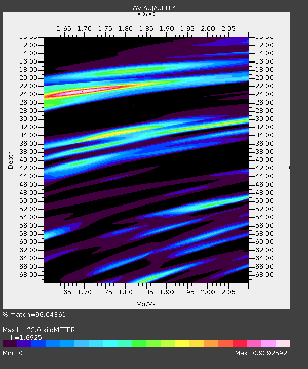
| Estimated Moho Depth: |
23.0 km |
| Estimated Crust Vp/Vs: |
1.69 |
| Assumed Crust Vp: |
5.989 km/s |
| Estimated Crust Vs: |
3.539 km/s |
| Estimated Crust Poisson's Ratio: |
0.23 |
|
| Radial Match: |
96.04361 % |
| Radial Bump: |
400 |
| Transverse Match: |
90.29294 % |
| Transverse Bump: |
400 |
| SOD ConfigId: |
11737051 |
| Insert Time: |
2019-04-26 16:38:25.559 +0000 |
| GWidth: |
2.5 |
| Max Bumps: |
400 |
| Tol: |
0.001 |
|

Signal To Noise
| Channel | StoN | STA | LTA |
| AV:AUJA: :BHZ:20170122T04:41:29.798997Z | 41.607594 | 2.3069548E-5 | 5.5445526E-7 |
| AV:AUJA: :BHN:20170122T04:41:29.798997Z | 6.0933084 | 7.951057E-6 | 1.3048834E-6 |
| AV:AUJA: :BHE:20170122T04:41:29.798997Z | 4.512545 | 7.4814116E-6 | 1.657914E-6 |
| Arrivals |
| Ps | 2.7 SECOND |
| PpPs | 10 SECOND |
| PsPs/PpSs | 13 SECOND |


