You are here: Home > Network List > AV - Alaska Volcano Observatory Stations List
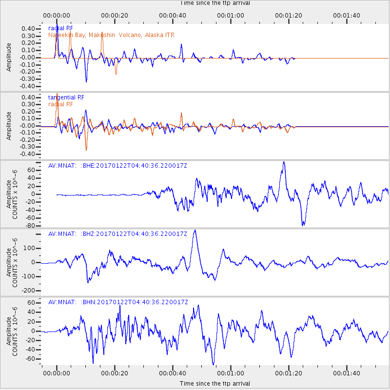
> Station MNAT Nateekin Bay, Makushin Volcano, Alaska > Earthquake Result Viewer
MNAT Nateekin Bay, Makushin Volcano, Alaska - Earthquake Result Viewer
| Earthquake location: |
Solomon Islands |
| Earthquake latitude/longitude: |
-6.2/155.1 |
| Earthquake time(UTC): |
2017/01/22 (022) 04:30:23 GMT |
| Earthquake Depth: |
136 km |
| Earthquake Magnitude: |
7.9 mww |
| Earthquake Catalog/Contributor: |
NEIC PDE/us |
|
| Network: |
AV Alaska Volcano Observatory |
| Station: |
MNAT Nateekin Bay, Makushin Volcano, Alaska |
| Lat/Lon: |
53.88 N/166.69 W |
| Elevation: |
390 m |
|
| Distance: |
67.9 deg |
| Az: |
23.267 deg |
| Baz: |
221.558 deg |
| Ray Param: |
0.056277666 |
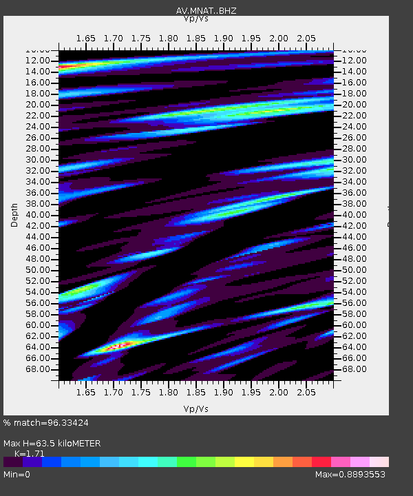
| Estimated Moho Depth: |
63.5 km |
| Estimated Crust Vp/Vs: |
1.71 |
| Assumed Crust Vp: |
3.943 km/s |
| Estimated Crust Vs: |
2.306 km/s |
| Estimated Crust Poisson's Ratio: |
0.24 |
|
| Radial Match: |
96.33424 % |
| Radial Bump: |
400 |
| Transverse Match: |
90.17582 % |
| Transverse Bump: |
400 |
| SOD ConfigId: |
11737051 |
| Insert Time: |
2019-04-26 16:38:34.680 +0000 |
| GWidth: |
2.5 |
| Max Bumps: |
400 |
| Tol: |
0.001 |
|
Signal To Noise
| Channel | StoN | STA | LTA |
| AV:MNAT: :BHZ:20170122T04:40:36.220017Z | 22.143934 | 1.693629E-5 | 7.6482746E-7 |
| AV:MNAT: :BHN:20170122T04:40:36.220017Z | 8.228622 | 5.0219064E-6 | 6.102973E-7 |
| AV:MNAT: :BHE:20170122T04:40:36.220017Z | 8.885153 | 5.100715E-6 | 5.7407175E-7 |
| Arrivals |
| Ps | 12 SECOND |
| PpPs | 43 SECOND |
| PsPs/PpSs | 55 SECOND |


