You are here: Home > Network List > AV - Alaska Volcano Observatory Stations List
> Station WECS Cape Sarichef, Westdahl Peak, Alaska > Earthquake Result Viewer
WECS Cape Sarichef, Westdahl Peak, Alaska - Earthquake Result Viewer
| Earthquake location: |
Solomon Islands |
| Earthquake latitude/longitude: |
-6.2/155.1 |
| Earthquake time(UTC): |
2017/01/22 (022) 04:30:23 GMT |
| Earthquake Depth: |
136 km |
| Earthquake Magnitude: |
7.9 mww |
| Earthquake Catalog/Contributor: |
NEIC PDE/us |
|
| Network: |
AV Alaska Volcano Observatory |
| Station: |
WECS Cape Sarichef, Westdahl Peak, Alaska |
| Lat/Lon: |
54.53 N/164.78 W |
| Elevation: |
639 m |
|
| Distance: |
69.2 deg |
| Az: |
23.686 deg |
| Baz: |
223.254 deg |
| Ray Param: |
0.05547187 |
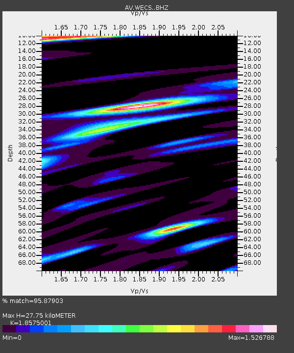
| Estimated Moho Depth: |
27.75 km |
| Estimated Crust Vp/Vs: |
1.86 |
| Assumed Crust Vp: |
5.989 km/s |
| Estimated Crust Vs: |
3.224 km/s |
| Estimated Crust Poisson's Ratio: |
0.30 |
|
| Radial Match: |
95.87903 % |
| Radial Bump: |
400 |
| Transverse Match: |
91.434364 % |
| Transverse Bump: |
400 |
| SOD ConfigId: |
11737051 |
| Insert Time: |
2019-04-26 16:38:43.171 +0000 |
| GWidth: |
2.5 |
| Max Bumps: |
400 |
| Tol: |
0.001 |
|

Signal To Noise
| Channel | StoN | STA | LTA |
| AV:WECS: :BHZ:20170122T04:40:43.858994Z | 13.167976 | 1.6643098E-5 | 1.2639069E-6 |
| AV:WECS: :BHN:20170122T04:40:43.858994Z | 1.7689561 | 2.937752E-6 | 1.6607264E-6 |
| AV:WECS: :BHE:20170122T04:40:43.858994Z | 4.13375 | 7.1746704E-6 | 1.7356325E-6 |
| Arrivals |
| Ps | 4.1 SECOND |
| PpPs | 13 SECOND |
| PsPs/PpSs | 17 SECOND |


