You are here: Home > Network List > CI - Caltech Regional Seismic Network Stations List
> Station DJJ Donna Jones Jenkins, California, USA > Earthquake Result Viewer
DJJ Donna Jones Jenkins, California, USA - Earthquake Result Viewer
| Earthquake location: |
Samoa Islands Region |
| Earthquake latitude/longitude: |
-16.6/-172.0 |
| Earthquake time(UTC): |
2006/09/28 (271) 06:22:09 GMT |
| Earthquake Depth: |
28 km |
| Earthquake Magnitude: |
6.5 MB, 6.6 MS, 6.9 MW, 6.7 MW |
| Earthquake Catalog/Contributor: |
WHDF/NEIC |
|
| Network: |
CI Caltech Regional Seismic Network |
| Station: |
DJJ Donna Jones Jenkins, California, USA |
| Lat/Lon: |
34.11 N/118.45 W |
| Elevation: |
245 m |
|
| Distance: |
71.7 deg |
| Az: |
44.688 deg |
| Baz: |
234.36 deg |
| Ray Param: |
0.054114297 |
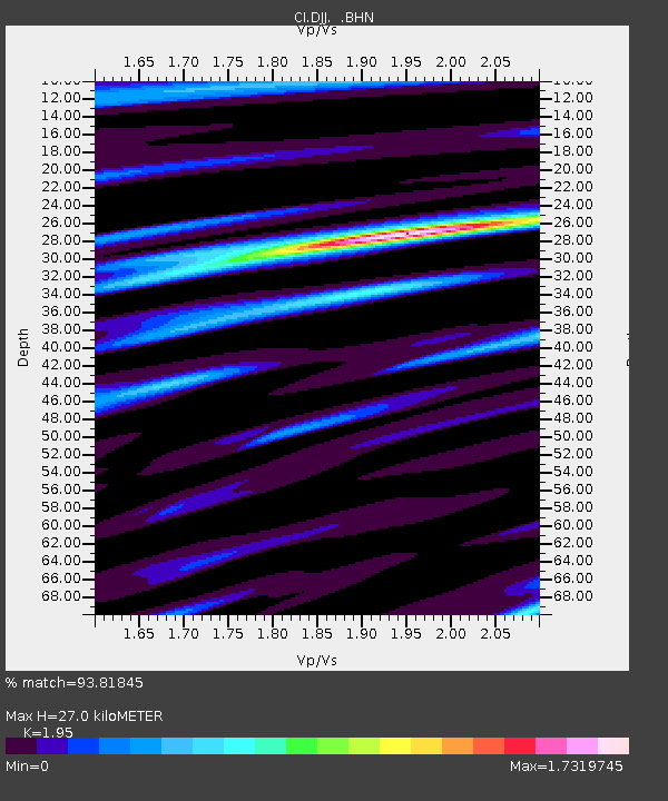
| Estimated Moho Depth: |
27.0 km |
| Estimated Crust Vp/Vs: |
1.95 |
| Assumed Crust Vp: |
6.1 km/s |
| Estimated Crust Vs: |
3.128 km/s |
| Estimated Crust Poisson's Ratio: |
0.32 |
|
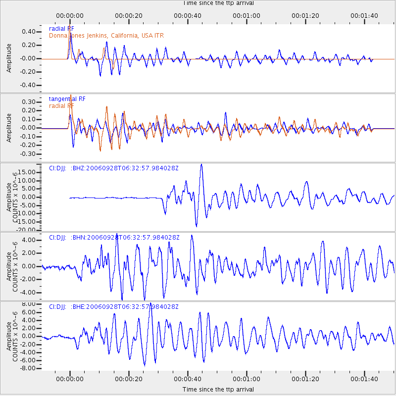
| Radial Match: |
93.81845 % |
| Radial Bump: |
400 |
| Transverse Match: |
88.767944 % |
| Transverse Bump: |
400 |
| SOD ConfigId: |
2665 |
| Insert Time: |
2010-03-05 21:46:05.002 +0000 |
| GWidth: |
2.5 |
| Max Bumps: |
400 |
| Tol: |
0.001 |
|
Signal To Noise
| Channel | StoN | STA | LTA |
| CI:DJJ: :BHN:20060928T06:32:57.984028Z | 4.7756844 | 8.71721E-7 | 1.825332E-7 |
| CI:DJJ: :BHE:20060928T06:32:57.984028Z | 5.1251493 | 1.2799675E-6 | 2.497425E-7 |
| CI:DJJ: :BHZ:20060928T06:32:57.984028Z | 24.717543 | 3.687696E-6 | 1.4919347E-7 |
| Arrivals |
| Ps | 4.3 SECOND |
| PpPs | 13 SECOND |
| PsPs/PpSs | 17 SECOND |


