You are here: Home > Network List > CB - China National Seismic Network Stations List
> Station DL2 Dalian,Liaoning Province > Earthquake Result Viewer
DL2 Dalian,Liaoning Province - Earthquake Result Viewer
| Earthquake location: |
Solomon Islands |
| Earthquake latitude/longitude: |
-6.2/155.1 |
| Earthquake time(UTC): |
2017/01/22 (022) 04:30:23 GMT |
| Earthquake Depth: |
136 km |
| Earthquake Magnitude: |
7.9 mww |
| Earthquake Catalog/Contributor: |
NEIC PDE/us |
|
| Network: |
CB China National Seismic Network |
| Station: |
DL2 Dalian,Liaoning Province |
| Lat/Lon: |
38.91 N/121.63 E |
| Elevation: |
65 m |
|
| Distance: |
54.6 deg |
| Az: |
328.103 deg |
| Baz: |
137.677 deg |
| Ray Param: |
0.06491716 |
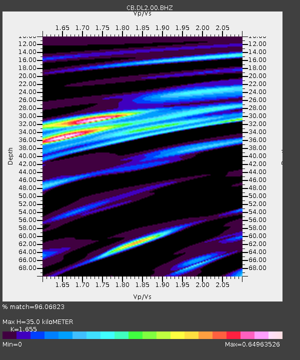
| Estimated Moho Depth: |
35.0 km |
| Estimated Crust Vp/Vs: |
1.65 |
| Assumed Crust Vp: |
6.134 km/s |
| Estimated Crust Vs: |
3.706 km/s |
| Estimated Crust Poisson's Ratio: |
0.21 |
|
| Radial Match: |
96.06823 % |
| Radial Bump: |
400 |
| Transverse Match: |
81.15968 % |
| Transverse Bump: |
400 |
| SOD ConfigId: |
11737051 |
| Insert Time: |
2019-04-26 16:39:14.068 +0000 |
| GWidth: |
2.5 |
| Max Bumps: |
400 |
| Tol: |
0.001 |
|

Signal To Noise
| Channel | StoN | STA | LTA |
| CB:DL2:00:BHZ:20170122T04:39:06.739976Z | 20.129473 | 2.8920349E-5 | 1.4367166E-6 |
| CB:DL2:00:BHN:20170122T04:39:06.739976Z | 12.952885 | 1.0639032E-5 | 8.2136387E-7 |
| CB:DL2:00:BHE:20170122T04:39:06.739976Z | 14.791267 | 1.0365056E-5 | 7.007551E-7 |
| Arrivals |
| Ps | 3.9 SECOND |
| PpPs | 14 SECOND |
| PsPs/PpSs | 18 SECOND |


