You are here: Home > Network List > CI - Caltech Regional Seismic Network Stations List
> Station GLA Glamis, Glamis, CA, USA > Earthquake Result Viewer
GLA Glamis, Glamis, CA, USA - Earthquake Result Viewer
| Earthquake location: |
Solomon Islands |
| Earthquake latitude/longitude: |
-6.2/155.1 |
| Earthquake time(UTC): |
2017/01/22 (022) 04:30:23 GMT |
| Earthquake Depth: |
136 km |
| Earthquake Magnitude: |
7.9 mww |
| Earthquake Catalog/Contributor: |
NEIC PDE/us |
|
| Network: |
CI Caltech Regional Seismic Network |
| Station: |
GLA Glamis, Glamis, CA, USA |
| Lat/Lon: |
33.05 N/114.83 W |
| Elevation: |
610 m |
|
| Distance: |
93.4 deg |
| Az: |
57.28 deg |
| Baz: |
264.837 deg |
| Ray Param: |
0.041193716 |
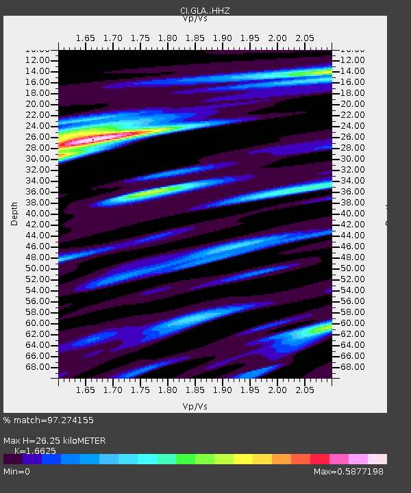
| Estimated Moho Depth: |
26.25 km |
| Estimated Crust Vp/Vs: |
1.66 |
| Assumed Crust Vp: |
6.155 km/s |
| Estimated Crust Vs: |
3.702 km/s |
| Estimated Crust Poisson's Ratio: |
0.22 |
|
| Radial Match: |
97.274155 % |
| Radial Bump: |
400 |
| Transverse Match: |
87.60646 % |
| Transverse Bump: |
400 |
| SOD ConfigId: |
11737051 |
| Insert Time: |
2019-04-26 16:39:43.886 +0000 |
| GWidth: |
2.5 |
| Max Bumps: |
400 |
| Tol: |
0.001 |
|

Signal To Noise
| Channel | StoN | STA | LTA |
| CI:GLA: :HHZ:20170122T04:42:51.497971Z | 3.9473596 | 4.9719206E-6 | 1.259556E-6 |
| CI:GLA: :HHN:20170122T04:42:51.497971Z | 1.3121644 | 6.214916E-7 | 4.7363852E-7 |
| CI:GLA: :HHE:20170122T04:42:51.497971Z | 2.5504062 | 1.6540632E-6 | 6.4854896E-7 |
| Arrivals |
| Ps | 2.9 SECOND |
| PpPs | 11 SECOND |
| PsPs/PpSs | 14 SECOND |


