You are here: Home > Network List > CI - Caltech Regional Seismic Network Stations List
> Station IKP In-Ko-Pah, Jacumba, CA, USA > Earthquake Result Viewer
IKP In-Ko-Pah, Jacumba, CA, USA - Earthquake Result Viewer
| Earthquake location: |
Solomon Islands |
| Earthquake latitude/longitude: |
-6.2/155.1 |
| Earthquake time(UTC): |
2017/01/22 (022) 04:30:23 GMT |
| Earthquake Depth: |
136 km |
| Earthquake Magnitude: |
7.9 mww |
| Earthquake Catalog/Contributor: |
NEIC PDE/us |
|
| Network: |
CI Caltech Regional Seismic Network |
| Station: |
IKP In-Ko-Pah, Jacumba, CA, USA |
| Lat/Lon: |
32.65 N/116.11 W |
| Elevation: |
906 m |
|
| Distance: |
92.3 deg |
| Az: |
57.575 deg |
| Baz: |
264.13 deg |
| Ray Param: |
0.041413344 |
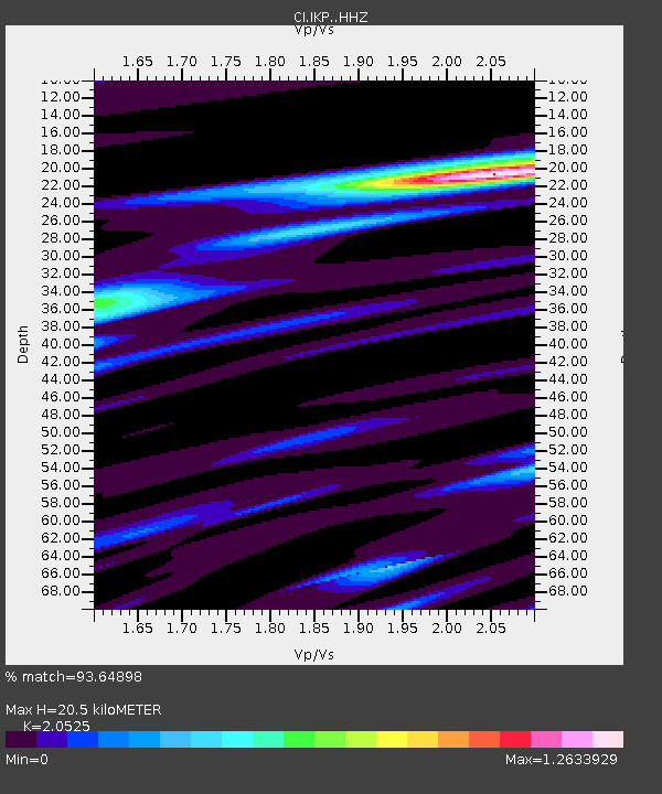
| Estimated Moho Depth: |
20.5 km |
| Estimated Crust Vp/Vs: |
2.05 |
| Assumed Crust Vp: |
6.264 km/s |
| Estimated Crust Vs: |
3.052 km/s |
| Estimated Crust Poisson's Ratio: |
0.34 |
|
| Radial Match: |
93.64898 % |
| Radial Bump: |
400 |
| Transverse Match: |
86.899956 % |
| Transverse Bump: |
400 |
| SOD ConfigId: |
11737051 |
| Insert Time: |
2019-04-26 16:39:48.791 +0000 |
| GWidth: |
2.5 |
| Max Bumps: |
400 |
| Tol: |
0.001 |
|

Signal To Noise
| Channel | StoN | STA | LTA |
| CI:IKP: :HHZ:20170122T04:42:46.387986Z | 5.4871492 | 6.0855527E-6 | 1.1090555E-6 |
| CI:IKP: :HHN:20170122T04:42:46.387986Z | 0.607389 | 4.133467E-7 | 6.805305E-7 |
| CI:IKP: :HHE:20170122T04:42:46.387986Z | 1.5580894 | 1.4815854E-6 | 9.508988E-7 |
| Arrivals |
| Ps | 3.5 SECOND |
| PpPs | 9.8 SECOND |
| PsPs/PpSs | 13 SECOND |


